
Topografische Karte Granity
Interaktive Karte
Klicken Sie auf die Karte, um die Höhe anzuzeigen.
Über diese Karte
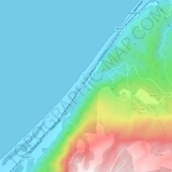
Name: Topografische Karte Granity, Höhe, Relief.
Ort: Granity, Buller District, West Coast, New Zealand (-41.65017 171.83495 -41.61017 171.87495)
Durchschnittliche Höhe: 150 m
Minimale Höhe: 0 m
Maximale Höhe: 638 m
Andere topografische Karten
Klicken Sie auf eine Karte, um ihre Topografie, ihre Höhe und ihr Relief anzuzeigen.
Charleston
New Zealand > West Coast > Buller District
Charleston, Buller District, West Coast, New Zealand
Durchschnittliche Höhe: 24 m
Mokihinui
New Zealand > West Coast > Buller District
Mokihinui, Buller District, West Coast, New Zealand
Durchschnittliche Höhe: 55 m
Lewis Pass
New Zealand > West Coast > Buller District
Lewis Pass, Buller District, West Coast, New Zealand
Durchschnittliche Höhe: 1.039 m
Cape Foulwind
New Zealand > West Coast > Buller District > Cape Foulwind
Cape Foulwind, Buller District, West Coast, New Zealand
Durchschnittliche Höhe: 14 m
Hukarere
New Zealand > West Coast > Buller District
Hukarere, Buller District, West Coast, New Zealand
Durchschnittliche Höhe: 131 m
Ikamatua
New Zealand > West Coast > Buller District
Ikamatua, Buller District, West Coast, New Zealand
Durchschnittliche Höhe: 122 m
Westport
New Zealand > West Coast > Buller District
Westport, Buller District, West Coast, 7825, New Zealand
Durchschnittliche Höhe: 13 m
Reefton
New Zealand > West Coast > Buller District
Reefton, Buller District, West Coast, 7830, New Zealand
Durchschnittliche Höhe: 310 m