
Topografische Karte Reefton
Interaktive Karte
Klicken Sie auf die Karte, um die Höhe anzuzeigen.
Über diese Karte
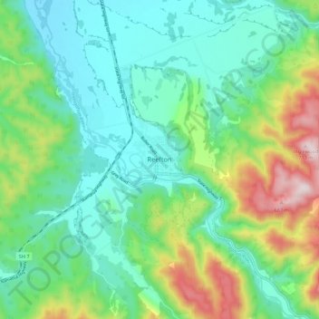
Name: Topografische Karte Reefton, Höhe, Relief.
Ort: Reefton, Buller District, West Coast, 7830, New Zealand (-42.15594 171.82346 -42.07594 171.90346)
Durchschnittliche Höhe: 310 m
Minimale Höhe: 156 m
Maximale Höhe: 713 m
Located in the Inangahua Valley at an altitude of 194m, Reefton falls under the Köppen-Geiger climate classification of Cfb (Oceanic). At an average temperature of 15.9 °C, February is the warmest month. July is the coldest month, at 6.8 °C. Reefton's average annual temperature is 11.4 °C. On average, snowfall occurs on 1.4 days annually, and an average of 22.1 days per year will exceed 26.7 °C (80 °F). During an average winter, Reefton can expect to see 47 days of frost.
Andere topografische Karten
Klicken Sie auf eine Karte, um ihre Topografie, ihre Höhe und ihr Relief anzuzeigen.
Mokihinui
New Zealand > West Coast > Buller District
Mokihinui, Buller District, West Coast, New Zealand
Durchschnittliche Höhe: 55 m
Charleston
New Zealand > West Coast > Buller District
Charleston, Buller District, West Coast, New Zealand
Durchschnittliche Höhe: 24 m
Granity
New Zealand > West Coast > Buller District
Granity, Buller District, West Coast, New Zealand
Durchschnittliche Höhe: 150 m
Lewis Pass
New Zealand > West Coast > Buller District
Lewis Pass, Buller District, West Coast, New Zealand
Durchschnittliche Höhe: 1.039 m
Cape Foulwind
New Zealand > West Coast > Buller District > Cape Foulwind
Cape Foulwind, Buller District, West Coast, New Zealand
Durchschnittliche Höhe: 14 m
Hukarere
New Zealand > West Coast > Buller District
Hukarere, Buller District, West Coast, New Zealand
Durchschnittliche Höhe: 131 m
Ikamatua
New Zealand > West Coast > Buller District
Ikamatua, Buller District, West Coast, New Zealand
Durchschnittliche Höhe: 122 m
Westport
New Zealand > West Coast > Buller District
Westport, Buller District, West Coast, 7825, New Zealand
Durchschnittliche Höhe: 13 m