
Topografische Karte Mount Makiling
Klicken Sie auf die Karte, um die Höhe anzuzeigen.
Mount Makiling
Mount Makiling (also spelled Maquiling) is an inactive stratovolcano located in the provinces of Laguna and Batangas on the island of Luzon in the Philippines. The mountain rises to an elevation of 1,090 meters (3,580 ft) above mean sea level and is the highest feature of the Laguna Volcanic Field. The volcano has no recorded historic eruption but volcanism is still evident through geothermal features like mud spring and hot springs. South of the mountain is the Makiling–Banahaw Geothermal Plant. The Philippine Institute of Volcanology and Seismology (PHIVOLCS) classifies the volcano as "Inactive".
Über diese Karte
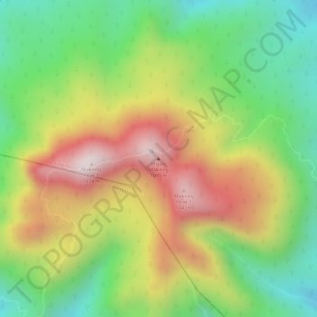
Name: Topografische Karte Mount Makiling, Höhe, Relief.
Ort: Mount Makiling, Los Baños, Laguna, Calabarzon, Philippines (14.13517 121.19440 14.13527 121.19450)
Durchschnittliche Höhe: 753 m
Minimale Höhe: 467 m
Maximale Höhe: 1.076 m
Andere topografische Karten
Klicken Sie auf eine Karte, um ihre Topografie, ihre Höhe und ihr Relief anzuzeigen.
UPLB CFNR Alumni Forest and Nature Park
Philippines > Laguna > Los Baños
Durchschnittliche Höhe: 148 m