
Spenden
Topografische Karte Gundelsbach
Klicken Sie auf die Karte, um die Höhe anzuzeigen.
Spenden
Über diese Karte
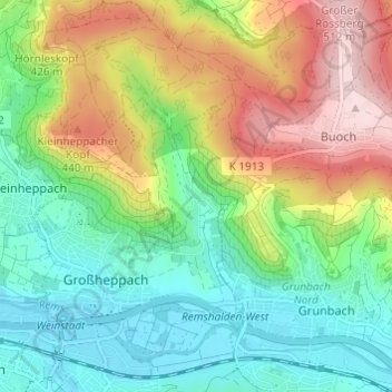
Name: Topografische Karte Gundelsbach, Höhe, Relief.
Durchschnittliche Höhe: 337 m
Minimale Höhe: 228 m
Maximale Höhe: 522 m
Spenden
Andere topografische Karten
Klicken Sie auf eine Karte, um ihre Topografie, ihre Höhe und ihr Relief anzuzeigen.
Spenden
Spiegelberg
Germany > Baden-Württemberg > Rems-Murr-Kreis
The municipality (Gemeinde) of Spiegelberg is located at the northern edge of the Rems-Murr district of Baden-Württemberg, along its border with the district of Heilbronn. Spiegelberg is situated in the valley of the Lauter and within the Swabian-Franconian Forest. Elevation above sea level in the municipal…
Durchschnittliche Höhe: 446 m
Spenden
Sulzbach an der Murr
Germany > Baden-Württemberg > Rems-Murr-Kreis
The municipality (Gemeinde) of Sulzbach an der Murr is located in the Rems-Murr district, in the German state of Baden-Württemberg. Sulzbach's municipal area is physically located in the between the Löwenstein Hills and Murrhardt Forest, regions of the greater Swabian-Franconian Forest. Elevation above sea…
Durchschnittliche Höhe: 396 m
Althütte
Germany > Baden-Württemberg > Rems-Murr-Kreis
The municipality (Gemeinde) of Althütte is located in the Rems-Murr district, in the German state of Baden-Württemberg. Althütte is physically located in the Murrhardt Forest, a region of the larger Swabian-Franconian Forest. Elevation above sea level in the municipal area ranges from a high of 571 meters…
Durchschnittliche Höhe: 464 m
Spenden
Backnang
Germany > Baden-Württemberg > Rems-Murr-Kreis
Before 1930 the title for this position was Stadtschultheiß. In 1930 the title became Bürgermeister (Mayor), and in 1956 with the elevation of Backnang to a "large district town," the title was changed to Oberbürgermeister (Lord Mayor).
Durchschnittliche Höhe: 302 m
Spenden