Geolokalisieren
👉 Easily get elevation data in JSON, GeoTIFF and KML formats using Elevation API
Vielen Dank für die Unterstützung dieser Website ❤️
Spenden

Topografische Karte Bramcote

Klicken Sie auf die Karte, um die Höhe anzuzeigen.

👉 Easily get elevation data in JSON, GeoTIFF and KML formats using Elevation API
Vielen Dank für die Unterstützung dieser Website ❤️
Spenden

Über diese Karte

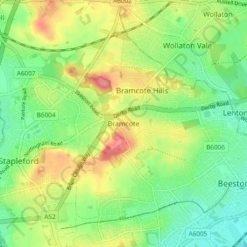
Name: Topografische Karte Bramcote, Höhe, Relief.

Ort: Bramcote, Broxtowe, Nottinghamshire, East Midlands, England, NG9 3HG, United Kingdom (52.91543 -1.26581 52.95543 -1.22581)

Durchschnittliche Höhe: 55 m

Minimale Höhe: 22 m

Maximale Höhe: 102 m

👉 Easily get elevation data in JSON, GeoTIFF and KML formats using Elevation API
Vielen Dank für die Unterstützung dieser Website ❤️
Spenden

Andere topografische Karten

Klicken Sie auf eine Karte, um ihre Topografie, ihre Höhe und ihr Relief anzuzeigen.

Manor House Pond

United Kingdom > England > Nottinghamshire > Broxtowe > Bramcote

Durchschnittliche Höhe: 57 m

Beeston

United Kingdom > England > Nottinghamshire > Broxtowe

Durchschnittliche Höhe: 39 m

Trowell

United Kingdom > England > Nottinghamshire > Broxtowe

Durchschnittliche Höhe: 62 m

Kimberley

United Kingdom > England > Nottinghamshire > Broxtowe

Durchschnittliche Höhe: 104 m

Vielen Dank für die Unterstützung dieser Website ❤️
Spenden

Nottingham Canal

United Kingdom > England > Nottinghamshire > Broxtowe

Durchschnittliche Höhe: 68 m

Brinsley

United Kingdom > England > Nottinghamshire > Broxtowe

Durchschnittliche Höhe: 100 m

Eastwood

United Kingdom > England > Nottinghamshire > Broxtowe > Newthorpe

Durchschnittliche Höhe: 81 m

Greasley

United Kingdom > England > Nottinghamshire > Broxtowe

Durchschnittliche Höhe: 104 m

Vielen Dank für die Unterstützung dieser Website ❤️
Spenden

Stapleford

United Kingdom > England > Nottinghamshire > Broxtowe

Durchschnittliche Höhe: 54 m

River Erewash

United Kingdom > England > Nottinghamshire > Broxtowe

The approximate meaning of the name is not in doubt, but there is room for debate about the precise derivation and its connotations. Brewer gives the commonly accepted explanation that it comes from the Old English words irre ("wandering") and wisce ("wet meadow"). This is accepted by Kenneth Cameron, a…

Durchschnittliche Höhe: 87 m

Strelley

United Kingdom > England > Nottinghamshire > Broxtowe > Strelley

Durchschnittliche Höhe: 100 m

Nuthall

United Kingdom > England > Nottinghamshire > Broxtowe

Durchschnittliche Höhe: 95 m

Vielen Dank für die Unterstützung dieser Website ❤️
Spenden

Cossall

United Kingdom > England > Nottinghamshire > Broxtowe

Durchschnittliche Höhe: 70 m

Eastwood

United Kingdom > England > Nottinghamshire > Broxtowe

Durchschnittliche Höhe: 81 m

Vielen Dank für die Unterstützung dieser Website ❤️
Spenden

Eastwood

United Kingdom > England > Nottinghamshire > Broxtowe

Durchschnittliche Höhe: 81 m