
Topografische Karte Dugadda
Klicken Sie auf die Karte, um die Höhe anzuzeigen.
Über diese Karte
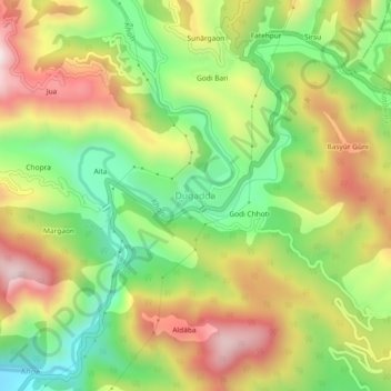
Name: Topografische Karte Dugadda, Höhe, Relief.
Ort: Dugadda, Kotdwara, Pauri Garhwal District, Uttarakhand, India (29.78701 78.58836 29.82701 78.62836)
Durchschnittliche Höhe: 896 m
Minimale Höhe: 594 m
Maximale Höhe: 1.246 m
Andere topografische Karten
Klicken Sie auf eine Karte, um ihre Topografie, ihre Höhe und ihr Relief anzuzeigen.
Ramganga Dam
India > Uttarakhand > Kotdwara
The dam is a 128 m (420 ft) tall and 630 m (2,067 ft) long earth and rock-fill embankment dam with 10,000,000 m3 (13,079,506 cu yd) of fill. The dam's spillway is controlled by five gates and has a maximum discharge of 8,467 m3/s (299,009 cu ft/s). To support the reservoir's elevation, there is a 72 m (236 ft)…
Durchschnittliche Höhe: 389 m