
Spenden
Topografische Karte Ramganga Dam
Klicken Sie auf die Karte, um die Höhe anzuzeigen.
Spenden
Ramganga Dam
The dam is a 128 m (420 ft) tall and 630 m (2,067 ft) long earth and rock-fill embankment dam with 10,000,000 m3 (13,079,506 cu yd) of fill. The dam's spillway is controlled by five gates and has a maximum discharge of 8,467 m3/s (299,009 cu ft/s). To support the reservoir's elevation, there is a 72 m (236 ft) tall saddle dam on the reservoir's rim 2.5 km (2 mi) to the northeast on the Chui Sot River. The reservoir created by both dams has a 244,700,000 m3 (198,382 acre⋅ft) capacity of which 219,000,000 m3 (177,546 acre⋅ft) is active (or "useful") capacity. The reservoir has a surface of 78.31 km2 (30 sq mi) and a catchment area of 3,134 km2 (1,210 sq mi). The power station at the toe of the dam contains three 66 MW Francis turbine-generators and is afforded 84.4 m (277 ft) of design hydraulic head. Below the dam is a system of over 6,300 km (3,915 mi) of canals supported by three barrages and 82 km (51 mi) of main feeder canal.
Spenden
Über diese Karte
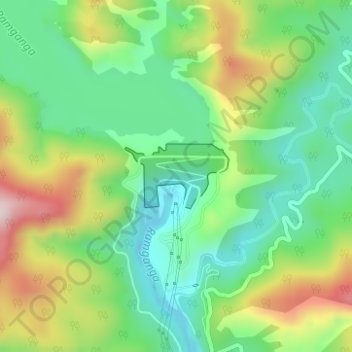
Name: Topografische Karte Ramganga Dam, Höhe, Relief.
Ort: Ramganga Dam, Kotdwara, Pauri Garhwal, Uttarakhand, India (29.51557 78.75378 29.52048 78.76286)
Durchschnittliche Höhe: 389 m
Minimale Höhe: 257 m
Maximale Höhe: 617 m
Spenden
Andere topografische Karten
Klicken Sie auf eine Karte, um ihre Topografie, ihre Höhe und ihr Relief anzuzeigen.
Kotdwar
India > Uttarakhand > Kotdwara
Kotdwar lies on the western margin of the Himalayas, at an altitude of 454 m (1,490 ft) above sea level.
Durchschnittliche Höhe: 471 m
Spenden
Spenden
Kotdwar
India > Uttarakhand > Kotdwara
Kotdwar lies on the western margin of the Himalayas, at an altitude of 454 m (1,490 ft) above sea level.
Durchschnittliche Höhe: 641 m
Kotdwar
India > Uttarakhand > Kotdwara
Kotdwar lies on the western margin of the Himalayas, at an altitude of 454 m (1,490 ft) above sea level.
Durchschnittliche Höhe: 471 m
Spenden
Kotdwar
India > Uttarakhand > Kotdwara
Kotdwar lies on the western margin of the Himalayas, at an altitude of 454 m (1,490 ft) above sea level.
Durchschnittliche Höhe: 471 m
Spenden