
Spenden
Topografische Karte Callaway
Klicken Sie auf die Karte, um die Höhe anzuzeigen.
Spenden
Über diese Karte
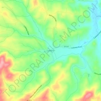
Name: Topografische Karte Callaway, Höhe, Relief.
Ort: Callaway, Franklin County, Virginia, 24067, United States (36.99153 -80.06948 37.03153 -80.02948)
Durchschnittliche Höhe: 398 m
Minimale Höhe: 345 m
Maximale Höhe: 477 m
Spenden
Andere topografische Karten
Klicken Sie auf eine Karte, um ihre Topografie, ihre Höhe und ihr Relief anzuzeigen.
Smith Mountain Lake
United States > Virginia > Franklin County > North Shore
Durchschnittliche Höhe: 275 m
Spenden
Boones Mill
United States > Virginia > Franklin County
According to the United States Census Bureau, the town has a total area of 0.73 square miles (1.9 km2), all of it land. The town is in the valley of Maggodee Creek, a southeast-flowing tributary of the Blackwater River, part of the Roanoke River watershed. Murray Knob, elevation 2,286 feet (697 m), rises 2…
Durchschnittliche Höhe: 390 m
Spenden