
Spenden
Topografische Karte Boones Mill
Klicken Sie auf die Karte, um die Höhe anzuzeigen.
Spenden
Boones Mill
According to the United States Census Bureau, the town has a total area of 0.73 square miles (1.9 km2), all of it land. The town is in the valley of Maggodee Creek, a southeast-flowing tributary of the Blackwater River, part of the Roanoke River watershed. Murray Knob, elevation 2,286 feet (697 m), rises 2 miles (3 km) to the north on the crest of the Blue Ridge, and the eastern end of Cahas Mountain, at 2,992 feet (912 m), is 2 miles to the west.
Spenden
Über diese Karte
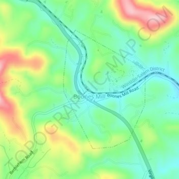
Name: Topografische Karte Boones Mill, Höhe, Relief.
Ort: Boones Mill, Franklin County, Virginia, United States (37.10687 -79.95893 37.12478 -79.94342)
Durchschnittliche Höhe: 390 m
Minimale Höhe: 326 m
Maximale Höhe: 506 m
Spenden
Andere topografische Karten
Klicken Sie auf eine Karte, um ihre Topografie, ihre Höhe und ihr Relief anzuzeigen.