
Topografische Karte Pampady
Interaktive Karte
Klicken Sie auf die Karte, um die Höhe anzuzeigen.
Über diese Karte
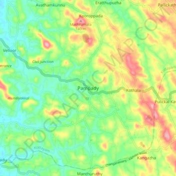
Name: Topografische Karte Pampady, Höhe, Relief.
Ort: Pampady, Kottayam, Kottayam District, Kerala, 686502, India (9.54563 76.62436 9.58563 76.66436)
Durchschnittliche Höhe: 55 m
Minimale Höhe: 17 m
Maximale Höhe: 135 m
Andere topografische Karten
Klicken Sie auf eine Karte, um ihre Topografie, ihre Höhe und ihr Relief anzuzeigen.
Nellikunnu
India > Kerala > Kottayam > Mattakkara
Nellikunnu, Mattakkara, Kottayam, Kerala, India
Durchschnittliche Höhe: 50 m