Geolokalisieren
👉 Easily get elevation data in JSON, GeoTIFF and KML formats using Elevation API
Vielen Dank für die Unterstützung dieser Website ❤️
Spenden

Topografische Karte Kumarakom

Klicken Sie auf die Karte, um die Höhe anzuzeigen.

👉 Easily get elevation data in JSON, GeoTIFF and KML formats using Elevation API
Vielen Dank für die Unterstützung dieser Website ❤️
Spenden

Über diese Karte

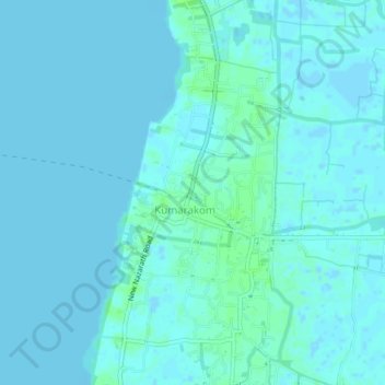
Name: Topografische Karte Kumarakom, Höhe, Relief.

Ort: Kumarakom, Kottayam, Kerala, 686563, India (9.57605 76.41054 9.61605 76.45054)

Durchschnittliche Höhe: 2 m

Minimale Höhe: -4 m

Maximale Höhe: 7 m

👉 Easily get elevation data in JSON, GeoTIFF and KML formats using Elevation API
Vielen Dank für die Unterstützung dieser Website ❤️
Spenden

Andere topografische Karten

Klicken Sie auf eine Karte, um ihre Topografie, ihre Höhe und ihr Relief anzuzeigen.

Sankranthi

India > Kerala > Kottayam > Kottayam

Durchschnittliche Höhe: 15 m

Meenadom

India > Kerala > Kottayam > Pariyaram

Durchschnittliche Höhe: 36 m

Manimala River

India > Kerala > Kottayam > Eravinalloor

Durchschnittliche Höhe: 12 m

Kanjikuzhy

India > Kerala > Kottayam > Manganam

Durchschnittliche Höhe: 14 m

Vielen Dank für die Unterstützung dieser Website ❤️
Spenden

Meenachil

India > Kerala > Kottayam > Pulikuttisseri

Durchschnittliche Höhe: 7 m

child

India > Kerala > Kottayam > Thiruvanchoor

Durchschnittliche Höhe: 13 m

Alapuzha

India > Kerala > Kottayam > Kottayam

Durchschnittliche Höhe: 10 m

Karapuzha

India > Kerala > Kottayam > Kottayam

Durchschnittliche Höhe: 7 m

Vielen Dank für die Unterstützung dieser Website ❤️
Spenden

Alapuzha

India > Kerala > Kottayam > Kottayam

Durchschnittliche Höhe: 10 m

Alapuzha

India > Kerala > Kottayam > Kottayam

Durchschnittliche Höhe: 10 m