
Topografische Karte Navan
Interaktive Karte
Klicken Sie auf die Karte, um die Höhe anzuzeigen.
Über diese Karte
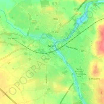
Name: Topografische Karte Navan, Höhe, Relief.
Durchschnittliche Höhe: 52 m
Minimale Höhe: 26 m
Maximale Höhe: 84 m
Andere topografische Karten
Klicken Sie auf eine Karte, um ihre Topografie, ihre Höhe und ihr Relief anzuzeigen.
Slane ED
Slane ED, The Municipal District of Laytown — Bettystown, Comté de Meath, Leinster, Irlande
Durchschnittliche Höhe: 79 m
Hill of Tara
Hill of Tara, The Municipal District of Ashbourne, Comté de Meath, Leinster, C15 NYY6, Irlande
Durchschnittliche Höhe: 106 m
The Municipal District of Navan
The Municipal District of Navan, Comté de Meath, Leinster, Irlande
Durchschnittliche Höhe: 62 m
The Municipal District of Ratoath
The Municipal District of Ratoath, Comté de Meath, Leinster, Irlande
Durchschnittliche Höhe: 87 m
Donore
Donore, Saint Mary's ED, The Municipal District of Laytown — Bettystown, Comté de Meath, Leinster, Irlande
Durchschnittliche Höhe: 58 m
Boyne
Boyne, Kilcooly ED, The Municipal District of Trim, Comté de Meath, Leinster, C15 X3Y2, Irlande
Durchschnittliche Höhe: 57 m
Bettystown
Bettystown, The Municipal District of Laytown — Bettystown, Comté de Meath, Leinster, A92 AH27, Irlande
Durchschnittliche Höhe: 6 m