
Topografische Karte The Municipal District of Navan
Interaktive Karte
Klicken Sie auf die Karte, um die Höhe anzuzeigen.
Über diese Karte
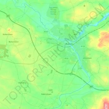
Name: Topografische Karte The Municipal District of Navan, Höhe, Relief.
Durchschnittliche Höhe: 62 m
Minimale Höhe: 22 m
Maximale Höhe: 154 m
Andere topografische Karten
Klicken Sie auf eine Karte, um ihre Topografie, ihre Höhe und ihr Relief anzuzeigen.
Navan
Navan, The Municipal District of Navan, Comté de Meath, Leinster, Irlande
Durchschnittliche Höhe: 52 m
Slane ED
Slane ED, The Municipal District of Laytown — Bettystown, Comté de Meath, Leinster, Irlande
Durchschnittliche Höhe: 79 m
Hill of Tara
Hill of Tara, The Municipal District of Ashbourne, Comté de Meath, Leinster, C15 NYY6, Irlande
Durchschnittliche Höhe: 106 m
The Municipal District of Ratoath
The Municipal District of Ratoath, Comté de Meath, Leinster, Irlande
Durchschnittliche Höhe: 87 m
Donore
Donore, Saint Mary's ED, The Municipal District of Laytown — Bettystown, Comté de Meath, Leinster, Irlande
Durchschnittliche Höhe: 58 m
Boyne
Boyne, Kilcooly ED, The Municipal District of Trim, Comté de Meath, Leinster, C15 X3Y2, Irlande
Durchschnittliche Höhe: 57 m
Bettystown
Bettystown, The Municipal District of Laytown — Bettystown, Comté de Meath, Leinster, A92 AH27, Irlande
Durchschnittliche Höhe: 6 m