
Spenden
Topografische Karte Killyberry Boyd
Klicken Sie auf die Karte, um die Höhe anzuzeigen.
Spenden
Über diese Karte
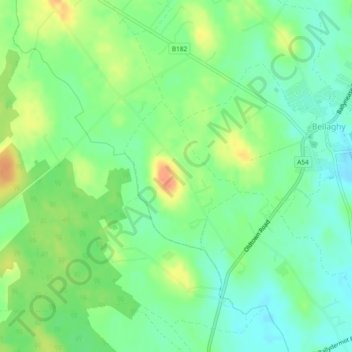
Name: Topografische Karte Killyberry Boyd, Höhe, Relief.
Ort: Killyberry Boyd, Northern Ireland, United Kingdom (54.79857 -6.54570 54.81004 -6.53044)
Durchschnittliche Höhe: 35 m
Minimale Höhe: 18 m
Maximale Höhe: 59 m
Spenden
Andere topografische Karten
Klicken Sie auf eine Karte, um ihre Topografie, ihre Höhe und ihr Relief anzuzeigen.
Spenden
Spenden
Derry/Londonderry
United Kingdom > Northern Ireland > County Londonderry
Derry is characterised by its distinctively hilly topography. The River Foyle forms a deep valley as it flows through the city, making Derry a place of very steep streets and sudden, startling views. The original walled city of Londonderry lies on a hill on the west bank of the River Foyle. In the past, the…
Durchschnittliche Höhe: 88 m
Spenden
Spenden
Spenden
Spenden
McLean's Hill
United Kingdom > Northern Ireland > County Down > Bryansford
Durchschnittliche Höhe: 93 m
Spenden