Geolokalisieren
👉 Easily get elevation data in JSON, GeoTIFF and KML formats using Elevation API
Vielen Dank für die Unterstützung dieser Website ❤️
Spenden

Topografische Karte Binian Lough

Klicken Sie auf die Karte, um die Höhe anzuzeigen.

👉 Easily get elevation data in JSON, GeoTIFF and KML formats using Elevation API
Vielen Dank für die Unterstützung dieser Website ❤️
Spenden

Über diese Karte

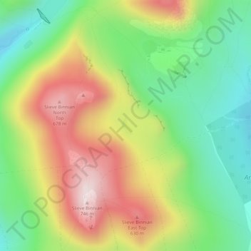
Name: Topografische Karte Binian Lough, Höhe, Relief.

Ort: Binian Lough, County Down, Northern Ireland, United Kingdom (54.14935 -5.97360 54.15117 -5.97168)

Durchschnittliche Höhe: 411 m

Minimale Höhe: 172 m

Maximale Höhe: 724 m

👉 Easily get elevation data in JSON, GeoTIFF and KML formats using Elevation API
Vielen Dank für die Unterstützung dieser Website ❤️
Spenden

Andere topografische Karten

Klicken Sie auf eine Karte, um ihre Topografie, ihre Höhe und ihr Relief anzuzeigen.

Attical

United Kingdom > Northern Ireland > County Down

Durchschnittliche Höhe: 155 m

Dromara

United Kingdom > Northern Ireland > County Down

Durchschnittliche Höhe: 149 m

Drumbo

United Kingdom > Northern Ireland > County Down

Durchschnittliche Höhe: 94 m

Clough

United Kingdom > Northern Ireland > County Down

Durchschnittliche Höhe: 32 m

Vielen Dank für die Unterstützung dieser Website ❤️
Spenden

Whiterock

United Kingdom > Northern Ireland > County Down

Durchschnittliche Höhe: 11 m

Carryduff

United Kingdom > Northern Ireland > County Down

Durchschnittliche Höhe: 110 m

Newry

United Kingdom > Northern Ireland > County Down > Newry

Durchschnittliche Höhe: 73 m

Groomsport

United Kingdom > Northern Ireland > County Down > Groomsport

Durchschnittliche Höhe: 10 m

Vielen Dank für die Unterstützung dieser Website ❤️
Spenden

Aughnahoory

United Kingdom > Northern Ireland > County Down > Kilkeel

Durchschnittliche Höhe: 60 m