
Topografische Karte Ohau Peak
Interaktive Karte
Klicken Sie auf die Karte, um die Höhe anzuzeigen.
Über diese Karte
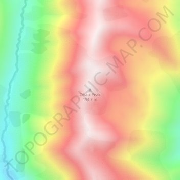
Name: Topografische Karte Ohau Peak, Höhe, Relief.
Ort: Ohau Peak, Waitaki District, Canterbury, New Zealand (-44.31774 169.76946 -44.31764 169.76956)
Durchschnittliche Höhe: 1.553 m
Minimale Höhe: 1.081 m
Maximale Höhe: 1.910 m
Andere topografische Karten
Klicken Sie auf eine Karte, um ihre Topografie, ihre Höhe und ihr Relief anzuzeigen.
Lindis Pass
New Zealand > Canterbury > Waitaki District
Lindis Pass, Waitaki District, Canterbury, New Zealand
Durchschnittliche Höhe: 1.011 m
Waitaki River
New Zealand > Canterbury > Waitaki District
Waitaki River, Waitaki District, Canterbury, New Zealand
Durchschnittliche Höhe: 178 m
Omarama
New Zealand > Canterbury > Waitaki District
Omarama, Waitaki District, Canterbury, 9412, New Zealand
Durchschnittliche Höhe: 460 m
Lake Ruataniwha
New Zealand > Canterbury > Waitaki District
Lake Ruataniwha, Waitaki District, Canterbury, New Zealand
Durchschnittliche Höhe: 491 m
Kurow
New Zealand > Canterbury > Waitaki District
Kurow, Waitaki District, Canterbury, 9435, New Zealand
Durchschnittliche Höhe: 274 m
Otematata
New Zealand > Canterbury > Waitaki District
Otematata, Waitaki District, Canterbury, New Zealand
Durchschnittliche Höhe: 343 m
Otiake River
New Zealand > Canterbury > Waitaki District
Otiake River, Waitaki District, Canterbury, New Zealand
Durchschnittliche Höhe: 226 m