
Topografische Karte Lindis Pass
Interaktive Karte
Klicken Sie auf die Karte, um die Höhe anzuzeigen.
Über diese Karte
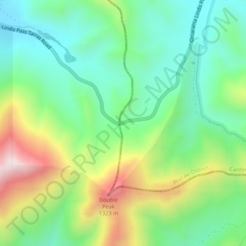
Name: Topografische Karte Lindis Pass, Höhe, Relief.
Ort: Lindis Pass, Waitaki District, Canterbury, New Zealand (-44.58831 169.64303 -44.58821 169.64313)
Durchschnittliche Höhe: 1.011 m
Minimale Höhe: 806 m
Maximale Höhe: 1.407 m
Lindis Pass (Māori: Ōmakō) (elevation 971 m) is located in the South Island of New Zealand. A carpark at the top of the pass provides access to a viewpoint and two short trails to other viewing spots.
Andere topografische Karten
Klicken Sie auf eine Karte, um ihre Topografie, ihre Höhe und ihr Relief anzuzeigen.
Ohau Peak
New Zealand > Canterbury > Waitaki District
Ohau Peak, Waitaki District, Canterbury, New Zealand
Durchschnittliche Höhe: 1.553 m
Waitaki River
New Zealand > Canterbury > Waitaki District
Waitaki River, Waitaki District, Canterbury, New Zealand
Durchschnittliche Höhe: 178 m
Omarama
New Zealand > Canterbury > Waitaki District
Omarama, Waitaki District, Canterbury, 9412, New Zealand
Durchschnittliche Höhe: 460 m
Lake Ruataniwha
New Zealand > Canterbury > Waitaki District
Lake Ruataniwha, Waitaki District, Canterbury, New Zealand
Durchschnittliche Höhe: 491 m
Kurow
New Zealand > Canterbury > Waitaki District
Kurow, Waitaki District, Canterbury, 9435, New Zealand
Durchschnittliche Höhe: 274 m
Otematata
New Zealand > Canterbury > Waitaki District
Otematata, Waitaki District, Canterbury, New Zealand
Durchschnittliche Höhe: 343 m
Otiake River
New Zealand > Canterbury > Waitaki District
Otiake River, Waitaki District, Canterbury, New Zealand
Durchschnittliche Höhe: 226 m