
Topografische Karte Salamanca
Interaktive Karte
Klicken Sie auf die Karte, um die Höhe anzuzeigen.
Über diese Karte
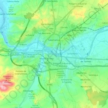
Name: Topografische Karte Salamanca, Höhe, Relief.
Ort: Salamanca, Castile and León, Spain (40.91463 -5.73580 40.99319 -5.62262)
Durchschnittliche Höhe: 812 m
Minimale Höhe: 763 m
Maximale Höhe: 935 m
The city is located at an altitude of 800 meters above sea level. The altitude of the municipality varies from 911 meters (Los Montalvos), in the southwest, and 763 meters in the last stretch in the municipality of the Tormes river.
Andere topografische Karten
Klicken Sie auf eine Karte, um ihre Topografie, ihre Höhe und ihr Relief anzuzeigen.
Arévalo
Arévalo, Ávila, Castile and León, 05200, Spain
Durchschnittliche Höhe: 845 m
La Maya
Spain > Castile and León > La Maya
La Maya, Tierra de Alba, Salamanca, Castile and León, Spain
Durchschnittliche Höhe: 850 m
Burgos
Spain > Castile and León > Burgos
Burgos, Alfoz de Burgos, Burgos, Castile and León, Spain
Durchschnittliche Höhe: 907 m
Atua
Spain > Castile and León > Condado de Treviño
Atua, Condado de Treviño, Ebro, Burgos, Castile and León, Spain
Durchschnittliche Höhe: 629 m
Contreras
Spain > Castile and León > Contreras
Contreras, Sierra de la Demanda, Burgos, Castile and León, Spain
Durchschnittliche Höhe: 1.089 m
El Espino
El Espino, Castile and León, 09219, Spain
Durchschnittliche Höhe: 732 m
Pico Almanzor
Spain > Castile and León > Candeleda
Pico Almanzor, Candeleda, Comarca de Arenas de San Pedro, Ávila, Castile and León, Spain
Durchschnittliche Höhe: 2.159 m