Topografische Karte Arévalo
Interaktive Karte
Klicken Sie auf die Karte, um die Höhe anzuzeigen.
Über diese Karte
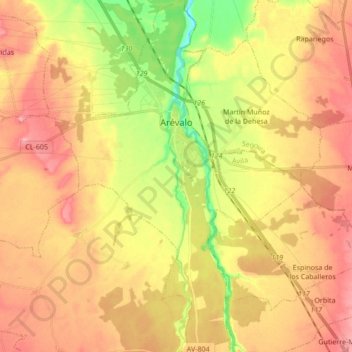
Name: Topografische Karte Arévalo, Höhe, Relief.
Ort: Arévalo, Ávila, Castile and León, 05200, Spain (40.97930 -4.77608 41.10759 -4.65959)
Durchschnittliche Höhe: 845 m
Minimale Höhe: 780 m
Maximale Höhe: 894 m
It is located at an altitude of 820 meters and is near the junction of the two rivers Adaja and Arevalillo. Its encompassed area is 46.07 km2 and its population is 13.122. In medieval times, it was the head of the agricultural sector (Comunidad de Villa y Tierra) of the same name.
Andere topografische Karten
Klicken Sie auf eine Karte, um ihre Topografie, ihre Höhe und ihr Relief anzuzeigen.
La Maya
Spain > Castile and León > La Maya
La Maya, Tierra de Alba, Salamanca, Castile and León, Spain
Durchschnittliche Höhe: 850 m
Burgos
Spain > Castile and León > Burgos
Burgos, Alfoz de Burgos, Burgos, Castile and León, Spain
Durchschnittliche Höhe: 907 m
Atua
Spain > Castile and León > Condado de Treviño
Atua, Condado de Treviño, Ebro, Burgos, Castile and León, Spain
Durchschnittliche Höhe: 629 m
Contreras
Spain > Castile and León > Contreras
Contreras, Sierra de la Demanda, Burgos, Castile and León, Spain
Durchschnittliche Höhe: 1.089 m
El Espino
El Espino, Castile and León, 09219, Spain
Durchschnittliche Höhe: 732 m
Pico Almanzor
Spain > Castile and León > Candeleda
Pico Almanzor, Candeleda, Comarca de Arenas de San Pedro, Ávila, Castile and León, Spain
Durchschnittliche Höhe: 2.159 m