
Spenden
Topografische Karte Dornsife
Klicken Sie auf die Karte, um die Höhe anzuzeigen.
Spenden
Über diese Karte
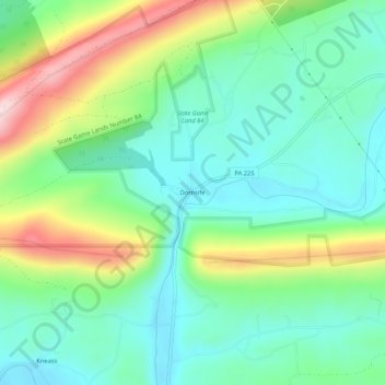
Name: Topografische Karte Dornsife, Höhe, Relief.
Ort: Dornsife, Northumberland County, Pennsylvania, United States (40.72564 -76.80914 40.76564 -76.76914)
Durchschnittliche Höhe: 238 m
Minimale Höhe: 139 m
Maximale Höhe: 455 m
Spenden
Andere topografische Karten
Klicken Sie auf eine Karte, um ihre Topografie, ihre Höhe und ihr Relief anzuzeigen.
Mount Carmel
United States > Pennsylvania > Northumberland County
Sawmill operator, Albert Bradford, gave Mount Carmel its name because of its elevation and beautiful setting in the mountains. He decided that it deserved a special name and named it after the holy mountain in Israel. Mount Carmel began as a logging town. Coal was only discovered in 1790 by Isaac Tomlinson. It…
Durchschnittliche Höhe: 380 m
Spenden
Riverside
United States > Pennsylvania > Northumberland County > Riverside
Durchschnittliche Höhe: 194 m
Spenden
Edgewood
United States > Pennsylvania > Northumberland County > Edgewood
Durchschnittliche Höhe: 297 m