
Spenden
Topografische Karte Mount Carmel
Klicken Sie auf die Karte, um die Höhe anzuzeigen.
Spenden
Mount Carmel
Sawmill operator, Albert Bradford, gave Mount Carmel its name because of its elevation and beautiful setting in the mountains. He decided that it deserved a special name and named it after the holy mountain in Israel. Mount Carmel began as a logging town. Coal was only discovered in 1790 by Isaac Tomlinson. It took twenty-four years until the first shipment of anthracite was shipped from the borough. Mount Carmel Inn was opened in 1812 by Richard Yarnall and was strategically located on the Centre Turnpike (also known as the Reading-Sunbury Road or Old Reading Road) halfway between Pottsville and Danville. During the latter part of 1854, the Philadelphia and Sunbury Railroad was completed from Shamokin to Mt. Carmel, which led to the opening and development of a number of collieries in the region. During the same year, the Locust Mountain Coal and Iron Company commenced making extensive openings and improvements upon their valuable coal lands in the vicinity of Mt. Carmel, building coal breakers for two collieries – the Coal Ridge and Locust Mountain collieries. The township was erected in 1854, formed from part of Coal Township; by 1862 the borough was incorporated within the township.
Spenden
Über diese Karte
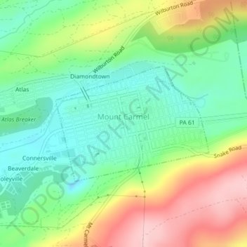
Name: Topografische Karte Mount Carmel, Höhe, Relief.
Durchschnittliche Höhe: 380 m
Minimale Höhe: 303 m
Maximale Höhe: 503 m
Spenden
Andere topografische Karten
Klicken Sie auf eine Karte, um ihre Topografie, ihre Höhe und ihr Relief anzuzeigen.
Shamokin
United States > Pennsylvania > Northumberland County > Shamokin
Durchschnittliche Höhe: 320 m
Overlook
United States > Pennsylvania > Northumberland County > Ralpho Township
Durchschnittliche Höhe: 261 m
Bear Gap
United States > Pennsylvania > Northumberland County > Ralpho Township > Bear Gap
Durchschnittliche Höhe: 317 m
Spenden
Fishers Ferry
United States > Pennsylvania > Northumberland County > Fishers Ferry
Durchschnittliche Höhe: 168 m
Spenden