
Spenden
Topografische Karte Reno No. 51
Klicken Sie auf die Karte, um die Höhe anzuzeigen.
Spenden
Reno No. 51
Govenlock-Nashlyn-Battle Creek Grasslands (SK 039) is an Important Bird Area (IBA) of Canada located at the south-western corner of the RM of Reno. It is a rectangular-shaped IBA site with the southern boundary running along the border with Montana. The western boundary runs up for 35 kilometres (22 mi) along the border with Alberta and the northern boundary extends towards the communities of Govenlock and Nashlyn and Battle Creek. From Nashlyn, it heads straight south back to the U.S. border. The site totals 840.03 km2 (324.34 sq mi) and has an elevation range of 903 to 1,001 metres. Access is from Highway 21.
Spenden
Über diese Karte
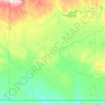
Name: Topografische Karte Reno No. 51, Höhe, Relief.
Ort: Reno No. 51, Division No. 4, Saskatchewan, Canada (48.99961 -110.00509 49.52464 -109.12257)
Durchschnittliche Höhe: 966 m
Minimale Höhe: 825 m
Maximale Höhe: 1.391 m
Spenden
Andere topografische Karten
Klicken Sie auf eine Karte, um ihre Topografie, ihre Höhe und ihr Relief anzuzeigen.
Valley Centre
Canada > Saskatchewan > Division No. 12 > Marriott No. 317
Durchschnittliche Höhe: 602 m
Spenden
Spenden
Whitecap Dakota First Nation
Canada > Saskatchewan > Whitecap Dakota First Nation
Durchschnittliche Höhe: 495 m
Morin Lake
Canada > Saskatchewan > Northern Saskatchewan Administration District > Morin Lake
Durchschnittliche Höhe: 385 m
Spenden
Black Lake
Canada > Saskatchewan > Northern Saskatchewan Administration District > Black Lake
Durchschnittliche Höhe: 293 m
Spenden
Spenden
La Loche
Canada > Saskatchewan > Northern Saskatchewan Administration District > La Loche
Durchschnittliche Höhe: 447 m
Waterloo Lake
Canada > Saskatchewan > Northern Saskatchewan Administration District
Durchschnittliche Höhe: 286 m
Spenden
Air Ronge
Canada > Saskatchewan > Northern Saskatchewan Administration District > Air Ronge
Durchschnittliche Höhe: 369 m
Garson Lake
Canada > Saskatchewan > Northern Saskatchewan Administration District > Garson Lake
Durchschnittliche Höhe: 470 m
Stony Rapids
Canada > Saskatchewan > Northern Saskatchewan Administration District
Durchschnittliche Höhe: 227 m
Spenden
Hall Lake
Canada > Saskatchewan > Northern Saskatchewan Administration District > Hall Lake
Durchschnittliche Höhe: 391 m
Zeden Lake
Canada > Saskatchewan > Northern Saskatchewan Administration District
Durchschnittliche Höhe: 526 m
Spenden