
Topografische Karte Beijing
Interaktive Karte
Klicken Sie auf die Karte, um die Höhe anzuzeigen.
Über diese Karte
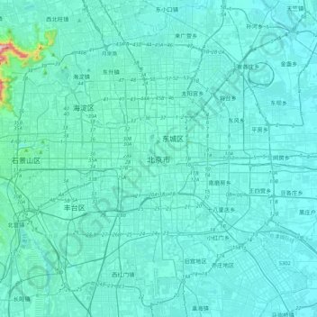
Name: Topografische Karte Beijing, Höhe, Relief.
Ort: Beijing, Dongcheng District, Beijing, 100010, China (39.74571 116.23130 40.06571 116.55130)
Durchschnittliche Höhe: 47 m
Minimale Höhe: 18 m
Maximale Höhe: 509 m
Beijing is situated at the northern tip of the roughly triangular North China Plain, which opens to the south and east of the city. Mountains to the north, northwest and west shield the city and northern China's agricultural heartland from the encroaching desert steppes. The northwestern part of the municipality, especially Yanqing District and Huairou District, are dominated by the Jundu Mountains, while the western part is framed by Xishan or the Western Hills. The Great Wall of China across the northern part of Beijing Municipality was built on the rugged topography to defend against nomadic incursions from the steppes. Mount Dongling, in the Western Hills and on the border with Hebei, is the municipality's highest point, with an altitude of 2,303 metres (7,556 ft).
Andere topografische Karten
Klicken Sie auf eine Karte, um ihre Topografie, ihre Höhe und ihr Relief anzuzeigen.
Xi'nanci
China > Beijing > Daxing District
Xi'nanci, Daxing District, Beijing, China
Durchschnittliche Höhe: 34 m
Yangtougang
China > Beijing > Fangshan District
Yangtougang, Fangshan District, Beijing, 102400, China
Durchschnittliche Höhe: 61 m
Yanqing District
China > Beijing > Yanqing District
Yanqing District, Beijing, China
Durchschnittliche Höhe: 742 m