
Topografische Karte Yanqing District
Interaktive Karte
Klicken Sie auf die Karte, um die Höhe anzuzeigen.
Über diese Karte
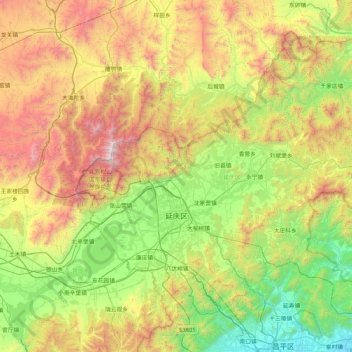
Name: Topografische Karte Yanqing District, Höhe, Relief.
Ort: Yanqing District, Beijing, China (40.26430 115.72974 40.78988 116.56832)
Durchschnittliche Höhe: 742 m
Minimale Höhe: 40 m
Maximale Höhe: 2.199 m
The Yanqing Badaling Great Wall Basin is surrounded by mountains on three sides in the north, south, east, and Guanting Reservoir to the west, namely the Yanhuai Basin. Yanqing is located in the east of the basin, with an average elevation of about 500 meters. Haituo Mountain is the highest peak in the territory, with an elevation of 2241 meters and the second highest peak in Beijing.