
Spenden
Topografische Karte Brecon Beacons National Park
Klicken Sie auf die Karte, um die Höhe anzuzeigen.
Spenden
Brecon Beacons National Park
Brecon Beacons National Park, officially named Bannau Brycheiniog National Park (Welsh pronunciation), is a national park in Wales. It is named after the Brecon Beacons (Welsh: Bannau Brycheiniog), the mountain range at its centre. The national park includes the highest mountain in South Wales, Pen y Fan, which has an elevation of 886 metres (2,907 ft).
Spenden
Über diese Karte
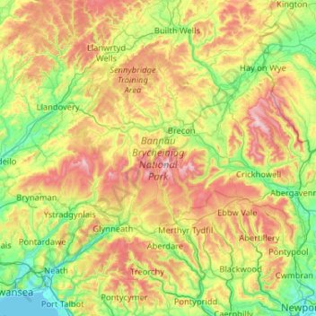
Name: Topografische Karte Brecon Beacons National Park, Höhe, Relief.
Ort: Brecon Beacons National Park, Powys, Wales, United Kingdom (51.70208 -3.98959 52.07830 -2.95207)
Durchschnittliche Höhe: 270 m
Minimale Höhe: 0 m
Maximale Höhe: 859 m
Spenden
Andere topografische Karten
Klicken Sie auf eine Karte, um ihre Topografie, ihre Höhe und ihr Relief anzuzeigen.
Welshpool
United Kingdom > Wales > Powys
The Mermaid Inn, 28 High Street, was very probably an early 16th-century merchant's house, placed on a burgage plot between the High Street and Alfred Jones Court. The timber-framed building has long storehouse or wing to the rear. The frontage was remodelled c. 1890, by Frank H. Shayler, architect, of…
Durchschnittliche Höhe: 156 m
Spenden
Knighton
United Kingdom > Wales > Powys
The town became a borough in 1203, with a charter permitting a weekly market and annual fair. The presence of two castles within a comparatively small town suggests that one (the earlier motte and bailey sited atop the town) went out of use before the establishment of the second (the motte with no bailey at…
Durchschnittliche Höhe: 295 m
Spenden
Spenden