
Topografische Karte Peñacerrada
Interaktive Karte
Klicken Sie auf die Karte, um die Höhe anzuzeigen.
Über diese Karte
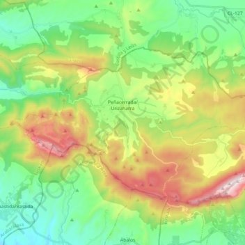
Name: Topografische Karte Peñacerrada, Höhe, Relief.
Ort: Peñacerrada, Montaña Alavesa, Álava, País Vasco, España (42.59485 -2.79536 42.67481 -2.61880)
Durchschnittliche Höhe: 767 m
Minimale Höhe: 446 m
Maximale Höhe: 1.364 m
Andere topografische Karten
Klicken Sie auf eine Karte, um ihre Topografie, ihre Höhe und ihr Relief anzuzeigen.
El Onzal
España > País Vasco > Montaña Alavesa > Campezo
El Onzal, Santa Cruz de Campezo, Campezo, Montaña Alavesa, Álava, País Vasco, 01110, España
Durchschnittliche Höhe: 612 m
Arraya-Maestu
España > País Vasco > Montaña Alavesa
Arraya-Maestu, Montaña Alavesa, Álava, País Vasco, España
Durchschnittliche Höhe: 821 m
Corres
España > País Vasco > Montaña Alavesa
Corres, Arraya-Maestu, Montaña Alavesa, Álava, País Vasco, 01120, España
Durchschnittliche Höhe: 745 m