
Topografische Karte Corres
Klicken Sie auf die Karte, um die Höhe anzuzeigen.
Über diese Karte
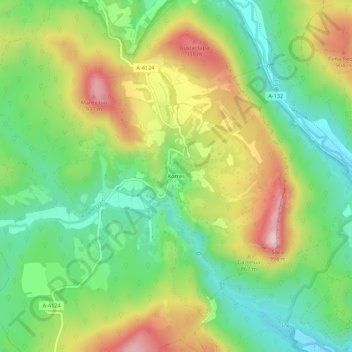
Name: Topografische Karte Corres, Höhe, Relief.
Durchschnittliche Höhe: 745 m
Minimale Höhe: 599 m
Maximale Höhe: 963 m
Andere topografische Karten
Klicken Sie auf eine Karte, um ihre Topografie, ihre Höhe und ihr Relief anzuzeigen.
Parque Natural de Izki
España > País Vasco > Montaña Alavesa > Apellániz
La máxima altitud de la zona es el monte Kapildui, con 1177 m s. n. m., siendo su cota mínima la parte más baja del río Izki, y 800 m s. n. m. la media del parque. Igualmente, destacan cotas como San Cristóbal (1057 m), San Justi (1028 m), Muela (1055 m), Soila (990 m), Belabia (970 m) y Mantxibio (937 m).
Durchschnittliche Höhe: 800 m
Lagrán
España > País Vasco > Montaña Alavesa
Lagrán se encuentra al sur de la provincia de Álava. Está situado a 756 m de altitud, y a menos de 3 km del pueblo hay alturas de más de 1400 m. Se encuentra en un valle en el cual nace el río Ega. La parte baja del valle está ocupada por cultivos de patata, cereal, etc. En las zonas marginales del valle…
Durchschnittliche Höhe: 810 m
Valle de Arana
España > País Vasco > Montaña Alavesa
La población de Contrasta se encuentra situada en la zona más estrecha de la entrada oriental del valle de Arana, cerrándolo por este extremo. Está emplazada sobre un promontorio a unos 825 m de altitud en un asentamiento privilegiado, que le permite dominar no solo el valle de Arana hacia el oeste, sino…
Durchschnittliche Höhe: 921 m
Oquina
España > País Vasco > Montaña Alavesa > Bernedo
Oquina (en euskera y oficialmente Okina) es un pueblo del municipio de Bernedo, en la provincia de Álava (País Vasco, España), ubicado a unos 15 kilómetros de Vitoria y a una altitud de unos 800 metros.
Durchschnittliche Höhe: 899 m