
Topografische Karte Cavehill
Interaktive Karte
Klicken Sie auf die Karte, um die Höhe anzuzeigen.
Über diese Karte
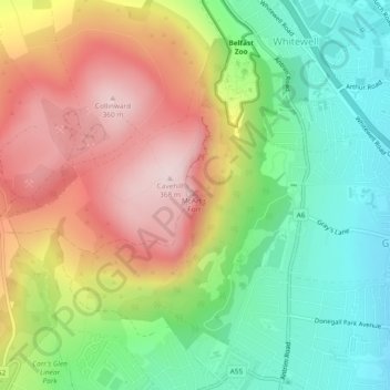
Name: Topografische Karte Cavehill, Höhe, Relief.
Durchschnittliche Höhe: 169 m
Minimale Höhe: 9 m
Maximale Höhe: 364 m
Andere topografische Karten
Klicken Sie auf eine Karte, um ihre Topografie, ihre Höhe und ihr Relief anzuzeigen.
Strangford Lough
United Kingdom > Northern Ireland > Belfast
Strangford Lough, Belfast, Northern Ireland, United Kingdom
Durchschnittliche Höhe: 0 m
The Maidens
United Kingdom > Northern Ireland > Belfast
The Maidens, Belfast, Northern Ireland, United Kingdom
Durchschnittliche Höhe: 0 m
Cloghcor
United Kingdom > Northern Ireland > Belfast
Cloghcor, Belfast, County Antrim, Northern Ireland, United Kingdom
Durchschnittliche Höhe: 295 m
Slemish
United Kingdom > Northern Ireland > Belfast
Slemish, Belfast, County Antrim, Northern Ireland, United Kingdom
Durchschnittliche Höhe: 249 m