
Topografische Karte Amber Valley
Klicken Sie auf die Karte, um die Höhe anzuzeigen.
Über diese Karte
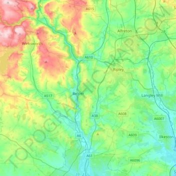
Name: Topografische Karte Amber Valley, Höhe, Relief.
Durchschnittliche Höhe: 133 m
Minimale Höhe: 41 m
Maximale Höhe: 367 m
Andere topografische Karten
Klicken Sie auf eine Karte, um ihre Topografie, ihre Höhe und ihr Relief anzuzeigen.
Hallam Moors
United Kingdom > England > Derbyshire > Derbyshire Dales > Hathersage
Durchschnittliche Höhe: 368 m
Robin Wood
United Kingdom > England > Derbyshire > South Derbyshire > Stanton by Bridge CP
Durchschnittliche Höhe: 92 m
Pistern Hill
United Kingdom > England > Derbyshire > South Derbyshire > Smisby
Durchschnittliche Höhe: 152 m
Heanor
United Kingdom > England > Derbyshire > Amber Valley
Samuel Lewis's A Topographical Dictionary of England, published in 1848, states that Heanor parish "abounds with coal and ironstone, both worked extensively, the collieries alone affording employment to more than 2000 persons. The town is pleasantly situated upon an eminence, on the road from Derby to…
Durchschnittliche Höhe: 102 m
Repton Shrubs
United Kingdom > England > Derbyshire > South Derbyshire > Repton CP
Durchschnittliche Höhe: 110 m
Crowden Great Brook
United Kingdom > England > Derbyshire > High Peak > Tintwistle > Crowden
Durchschnittliche Höhe: 314 m
Kinder Scout
United Kingdom > England > Derbyshire > High Peak
To the north across the Snake Pass lie the high moors of Bleaklow and Black Hill, which are of similar elevation.
Durchschnittliche Höhe: 555 m
Slaley
United Kingdom > England > Derbyshire > Derbyshire Dales > Matlock > Bonsall CP
Durchschnittliche Höhe: 263 m
Newhall Wood
United Kingdom > England > Derbyshire > South Derbyshire > Newhall
Durchschnittliche Höhe: 87 m
Denby Bottles
United Kingdom > England > Derbyshire > Amber Valley > Denby CP
Durchschnittliche Höhe: 108 m
Wain Stones
United Kingdom > England > Derbyshire > High Peak > Charlesworth
Durchschnittliche Höhe: 569 m
Denby Common
United Kingdom > England > Derbyshire > Amber Valley > Denby CP
Durchschnittliche Höhe: 116 m
Lightwood
United Kingdom > England > Derbyshire > North East Derbyshire > Eckington
Durchschnittliche Höhe: 168 m
Staunton Harold Reservoir
United Kingdom > England > Derbyshire > South Derbyshire > Melbourne CP
Durchschnittliche Höhe: 93 m
Bolehill
United Kingdom > England > Derbyshire > Derbyshire Dales > Wirksworth CP
Durchschnittliche Höhe: 220 m
Holymoorside
United Kingdom > England > Derbyshire > North East Derbyshire
Durchschnittliche Höhe: 199 m
Riber Castle
United Kingdom > England > Derbyshire > Derbyshire Dales > Matlock > Starkholmes
Durchschnittliche Höhe: 169 m
Creswell Model Village
United Kingdom > England > Derbyshire > Bolsover > Creswell Model Village
Durchschnittliche Höhe: 101 m
Inkersall
United Kingdom > England > Derbyshire > Chesterfield > Inkersall Green
Durchschnittliche Höhe: 87 m
Little Cubley
United Kingdom > England > Derbyshire > Cubley > Little Cubley
Durchschnittliche Höhe: 131 m
Parsley Hay
United Kingdom > England > Derbyshire > Derbyshire Dales > Parsley Hay
Durchschnittliche Höhe: 334 m
Eccles Pike
United Kingdom > England > Derbyshire > High Peak > Chapel-en-le-Frith > Whitehough > Whitehough Head
At the top of the hill is a commemorative plaque known as a topograph, showing a 360° relief of the surrounding landscape, placed by the community to mark the millennium. In early November 2011, the topograph was stolen. On 7 May 2013, it was replaced with one made from less valuable metal to discourage…
Durchschnittliche Höhe: 233 m
Arbor Low
United Kingdom > England > Derbyshire > Derbyshire Dales > Parsley Hay
Durchschnittliche Höhe: 342 m
Snake Pass
United Kingdom > England > Derbyshire > High Peak
Although Snake Pass is still the shortest route between Manchester and Sheffield, the more northerly Woodhead Pass, which is less steep and at a lower altitude, is now the primary road link between the two cities. Unlike Snake Pass, the Woodhead route is a trunk road. Traffic levels on both passes remained…
Durchschnittliche Höhe: 488 m
Newhaven
United Kingdom > England > Derbyshire > Derbyshire Dales > Biggin
Durchschnittliche Höhe: 332 m
Linton Heath
United Kingdom > England > Derbyshire > South Derbyshire > Linton
Durchschnittliche Höhe: 101 m
Two Dales
United Kingdom > England > Derbyshire > Derbyshire Dales > Darley Dale CP > Darley Hillside
Durchschnittliche Höhe: 189 m
Sutton Scarsdale
United Kingdom > England > Derbyshire > North East Derbyshire
Durchschnittliche Höhe: 109 m
Starkholmes
United Kingdom > England > Derbyshire > Derbyshire Dales > Matlock
Durchschnittliche Höhe: 175 m
Farley Wood
United Kingdom > England > Derbyshire > Derbyshire Dales > Matlock
Durchschnittliche Höhe: 255 m
Foremark Reservoir
United Kingdom > England > Derbyshire > South Derbyshire > Foremark CP
Durchschnittliche Höhe: 119 m
Magpie Mine
United Kingdom > England > Derbyshire > Derbyshire Dales > Ashford in the Water CP
Durchschnittliche Höhe: 303 m
Breadsall Hilltop
United Kingdom > England > Derbyshire > Erewash > Breadsall
Durchschnittliche Höhe: 82 m
Ogston Reservoir
United Kingdom > England > Derbyshire > North East Derbyshire > Woolley Moor
Durchschnittliche Höhe: 137 m
Ashover Hay
United Kingdom > England > Derbyshire > North East Derbyshire
Durchschnittliche Höhe: 198 m
Wakebridge
United Kingdom > England > Derbyshire > Amber Valley > Crich CP
Durchschnittliche Höhe: 181 m
Bamford Edge
United Kingdom > England > Derbyshire > High Peak > Bamford
Durchschnittliche Höhe: 289 m
Holme Moss
United Kingdom > England > Derbyshire > High Peak > Tintwistle
Durchschnittliche Höhe: 498 m
Doghole Wood
United Kingdom > England > Derbyshire > North East Derbyshire > Holymoorside
Durchschnittliche Höhe: 142 m
Botany Bay
United Kingdom > England > Derbyshire > South Derbyshire > Rosliston
Durchschnittliche Höhe: 95 m