
Topografische Karte Codnor Park
Klicken Sie auf die Karte, um die Höhe anzuzeigen.
Über diese Karte
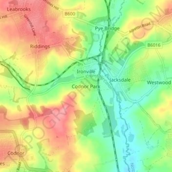
Name: Topografische Karte Codnor Park, Höhe, Relief.
Durchschnittliche Höhe: 106 m
Minimale Höhe: 63 m
Maximale Höhe: 153 m
Andere topografische Karten
Klicken Sie auf eine Karte, um ihre Topografie, ihre Höhe und ihr Relief anzuzeigen.
Nottingham Canal
United Kingdom > England > Derbyshire > Amber Valley > Langley Mill
Durchschnittliche Höhe: 77 m
Dethick, Lea and Holloway CP
United Kingdom > England > Derbyshire > Amber Valley > Dethick
Durchschnittliche Höhe: 204 m
Crich CP
United Kingdom > England > Derbyshire > Amber Valley
The memorial tower ('Crich Stand') was completed in 1923 as a memorial to the 11,409 soldiers from the Sherwood Foresters Regiment who died in World War I, a dedication that was later extended to include World War II. It was built on an limestone outcrop above the village, at an altitude of 1,000 feet (300 m)…
Durchschnittliche Höhe: 159 m
Shipley Country Park
United Kingdom > England > Derbyshire > Amber Valley > Marlpool
Durchschnittliche Höhe: 93 m
Lea Wood
United Kingdom > England > Derbyshire > Amber Valley > Lea Bridge
Durchschnittliche Höhe: 154 m
Alfreton Park
United Kingdom > England > Derbyshire > Amber Valley > Alfreton CP > Oakerthorpe
Durchschnittliche Höhe: 116 m
Horsley Woodhouse CP
United Kingdom > England > Derbyshire > Amber Valley
Durchschnittliche Höhe: 109 m
Crich Chase
United Kingdom > England > Derbyshire > Amber Valley > Crich CP
Durchschnittliche Höhe: 148 m