
Topografische Karte Eschdorf
Interaktive Karte
Klicken Sie auf die Karte, um die Höhe anzuzeigen.
Über diese Karte
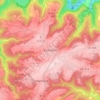
Name: Topografische Karte Eschdorf, Höhe, Relief.
Ort: Eschdorf, Esch-sur-Sûre, Canton Wiltz, 9151, Luxembourg (49.86448 5.91481 49.90448 5.95481)
Durchschnittliche Höhe: 456 m
Minimale Höhe: 268 m
Maximale Höhe: 525 m
Andere topografische Karten
Klicken Sie auf eine Karte, um ihre Topografie, ihre Höhe und ihr Relief anzuzeigen.
Pintsch
Luxembourg > Canton Wiltz > Kiischpelt
Pintsch, Kiischpelt, Canton Wiltz, 9767, Luxembourg
Durchschnittliche Höhe: 376 m
Pommerloch
Pommerloch, Winseler, Canton Wiltz, 9638, Luxembourg
Durchschnittliche Höhe: 442 m
Watrange
Luxembourg > Canton Wiltz > Lac de la Haute-Sûre
Watrange, Lac de la Haute-Sûre, Canton Wiltz, 9690, Luxembourg
Durchschnittliche Höhe: 468 m
Flebour
Flebour, Boulaide, Canton Wiltz, 9633, Luxembourg
Durchschnittliche Höhe: 426 m
Berlé
Berlé, Winseler, Canton Wiltz, 9636, Luxembourg
Durchschnittliche Höhe: 442 m
Esch-sur-Sûre
Esch-sur-Sûre, Canton Wiltz, Luxembourg
Durchschnittliche Höhe: 425 m