
Topografische Karte Wiltz
Interaktive Karte
Klicken Sie auf die Karte, um die Höhe anzuzeigen.
Über diese Karte
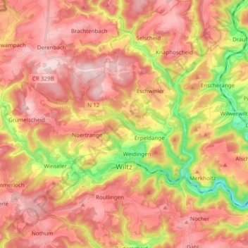
Name: Topografische Karte Wiltz, Höhe, Relief.
Ort: Wiltz, Canton Wiltz, Luxembourg (49.93454 5.87787 50.03223 5.98019)
Durchschnittliche Höhe: 423 m
Minimale Höhe: 257 m
Maximale Höhe: 530 m
La ville est traversée par la rivière Wiltz, un affluent de la Sûre. L'altitude varie entre 320 et 500 m.
Andere topografische Karten
Klicken Sie auf eine Karte, um ihre Topografie, ihre Höhe und ihr Relief anzuzeigen.
Pintsch
Luxembourg > Canton Wiltz > Kiischpelt
Pintsch, Kiischpelt, Canton Wiltz, 9767, Luxembourg
Durchschnittliche Höhe: 376 m
Pommerloch
Pommerloch, Winseler, Canton Wiltz, 9638, Luxembourg
Durchschnittliche Höhe: 442 m
Eschdorf
Eschdorf, Esch-sur-Sûre, Canton Wiltz, 9151, Luxembourg
Durchschnittliche Höhe: 456 m
Watrange
Luxembourg > Canton Wiltz > Lac de la Haute-Sûre
Watrange, Lac de la Haute-Sûre, Canton Wiltz, 9690, Luxembourg
Durchschnittliche Höhe: 468 m
Flebour
Flebour, Boulaide, Canton Wiltz, 9633, Luxembourg
Durchschnittliche Höhe: 426 m
Berlé
Berlé, Winseler, Canton Wiltz, 9636, Luxembourg
Durchschnittliche Höhe: 442 m
Esch-sur-Sûre
Esch-sur-Sûre, Canton Wiltz, Luxembourg
Durchschnittliche Höhe: 425 m