
Topografische Karte Kennesaw
Interaktive Karte
Klicken Sie auf die Karte, um die Höhe anzuzeigen.
Über diese Karte
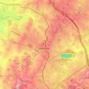
Name: Topografische Karte Kennesaw, Höhe, Relief.
Ort: Kennesaw, Cobb County, Georgia, United States (33.98696 -84.65002 34.06690 -84.58092)
Durchschnittliche Höhe: 317 m
Minimale Höhe: 167 m
Maximale Höhe: 393 m
Kennesaw is located in northwestern Cobb County, bordered by the city of Acworth to the northwest. Kennesaw Mountain is located southeast of the city limits in the battlefield park. Its summit is the highest point in the Atlanta metro area, at an elevation of 1,808 feet (551 m) above sea level. The city was renamed for the mountain.
Andere topografische Karten
Klicken Sie auf eine Karte, um ihre Topografie, ihre Höhe und ihr Relief anzuzeigen.
Marietta
United States > Georgia > Cobb County
Marietta, Cobb County, Georgia, United States
Durchschnittliche Höhe: 323 m
Aboretum
United States > Georgia > Cobb County
Aboretum, Cobb County, Georgia, United States
Durchschnittliche Höhe: 319 m
Marietta
United States > Georgia > Cobb County > Marietta
Marietta, Cobb County, Georgia, 30090, United States
Durchschnittliche Höhe: 302 m
Kennesaw
United States > Georgia > Cobb County > Kennesaw
Kennesaw, Cobb County, Georgia, 30144, United States
Durchschnittliche Höhe: 318 m
Powder Springs
United States > Georgia > Cobb County
Powder Springs, Cobb County, Georgia, United States
Durchschnittliche Höhe: 291 m
Vinings
United States > Georgia > Cobb County > Vinings
Vinings, Cobb County, Georgia, 30339, United States
Durchschnittliche Höhe: 281 m
Smyrna
United States > Georgia > Cobb County
Smyrna, Cobb County, Georgia, United States
Durchschnittliche Höhe: 289 m
Acworth
United States > Georgia > Cobb County
Acworth, Cobb County, Georgia, United States
Durchschnittliche Höhe: 281 m