
Topografische Karte Marietta
Interaktive Karte
Klicken Sie auf die Karte, um die Höhe anzuzeigen.
Über diese Karte
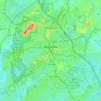
Name: Topografische Karte Marietta, Höhe, Relief.
Ort: Marietta, Cobb County, Georgia, United States (33.89559 -84.61681 34.00117 -84.46794)
Durchschnittliche Höhe: 323 m
Minimale Höhe: 274 m
Maximale Höhe: 532 m
Andere topografische Karten
Klicken Sie auf eine Karte, um ihre Topografie, ihre Höhe und ihr Relief anzuzeigen.
Aboretum
United States > Georgia > Cobb County
Aboretum, Cobb County, Georgia, United States
Durchschnittliche Höhe: 319 m
Kennesaw
United States > Georgia > Cobb County
Kennesaw, Cobb County, Georgia, United States
Durchschnittliche Höhe: 317 m
Marietta
United States > Georgia > Cobb County > Marietta
Marietta, Cobb County, Georgia, 30090, United States
Durchschnittliche Höhe: 302 m
Kennesaw
United States > Georgia > Cobb County > Kennesaw
Kennesaw, Cobb County, Georgia, 30144, United States
Durchschnittliche Höhe: 318 m
Powder Springs
United States > Georgia > Cobb County
Powder Springs, Cobb County, Georgia, United States
Durchschnittliche Höhe: 291 m
Vinings
United States > Georgia > Cobb County > Vinings
Vinings, Cobb County, Georgia, 30339, United States
Durchschnittliche Höhe: 281 m
Smyrna
United States > Georgia > Cobb County
Smyrna, Cobb County, Georgia, United States
Durchschnittliche Höhe: 289 m
Acworth
United States > Georgia > Cobb County
Acworth, Cobb County, Georgia, United States
Durchschnittliche Höhe: 281 m