
Topografische Karte Tilley Ridge
Interaktive Karte
Klicken Sie auf die Karte, um die Höhe anzuzeigen.
Über diese Karte
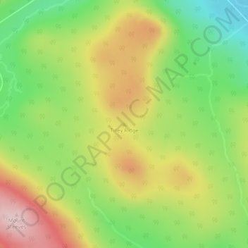
Name: Topografische Karte Tilley Ridge, Höhe, Relief.
Durchschnittliche Höhe: 591 m
Minimale Höhe: 452 m
Maximale Höhe: 750 m
Andere topografische Karten
Klicken Sie auf eine Karte, um ihre Topografie, ihre Höhe und ihr Relief anzuzeigen.
Tabusintac River
Canada > New Brunswick > Northumberland County
Tabusintac River, Northumberland County, New Brunswick, Canada
Durchschnittliche Höhe: 1 m
Glenwood
Canada > New Brunswick > Northumberland County
Glenwood, Glenelg Parish, Northumberland County, New Brunswick, Canada
Durchschnittliche Höhe: 39 m
Pineville
Canada > New Brunswick > Northumberland County
Pineville, Blackville Parish, Northumberland County, New Brunswick, Canada
Durchschnittliche Höhe: 38 m
Pleasant Ridge
Canada > New Brunswick > Northumberland County
Pleasant Ridge, Rogersville Parish, Northumberland County, New Brunswick, E4Y 2N2, Canada
Durchschnittliche Höhe: 89 m
Black Point
Canada > New Brunswick > Northumberland County
Black Point, Alnwick Parish, Northumberland County, New Brunswick, Canada
Durchschnittliche Höhe: 1 m
Priceville
Canada > New Brunswick > Northumberland County
Priceville, Ludlow Parish, Northumberland County, New Brunswick, Canada
Durchschnittliche Höhe: 99 m