
Topografische Karte Cornwall
Klicken Sie auf die Karte, um die Höhe anzuzeigen.
Über diese Karte
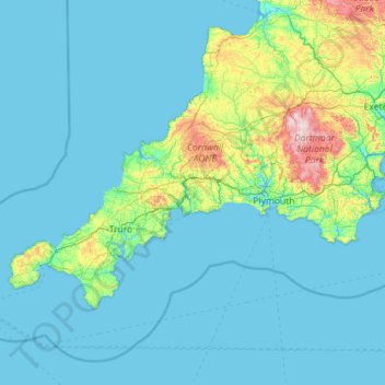
Name: Topografische Karte Cornwall, Höhe, Relief.
Ort: Cornwall, England, United Kingdom (49.86464 -6.44581 50.93127 -4.16494)
Durchschnittliche Höhe: 49 m
Minimale Höhe: -1 m
Maximale Höhe: 606 m
Andere topografische Karten
Klicken Sie auf eine Karte, um ihre Topografie, ihre Höhe und ihr Relief anzuzeigen.
City of London
United Kingdom > England > City of London > City of London
The elevation of the City ranges from sea level at the Thames to 21.6 metres (71 ft) at the junction of High Holborn and Chancery Lane. Two small but notable hills are within the historic core, Ludgate Hill to the west and Cornhill to the east. Between them ran the Walbrook, one of the many "lost" rivers or…
Durchschnittliche Höhe: 42 m
Shrewsbury
United Kingdom > England > Shrewsbury
Shrewsbury is about 14 miles (23 km) west of Telford, 43 miles (69 km) west of Birmingham and the West Midlands Conurbation, and about 153 miles (246 km) north-west of the capital, London. More locally, the town is to the east of Welshpool, with Bridgnorth and Kidderminster to the south-east. The border with…
Durchschnittliche Höhe: 71 m
Birmingham
United Kingdom > England > Birmingham
Birmingham is a snowy city relative to other large UK conurbations, due to its inland location and comparatively high elevation. Between 1961 and 1990 Birmingham Airport averaged 13.0 days of snow lying annually, compared to 5.33 at London Heathrow. Snow showers often pass through the city via the Cheshire gap…
Durchschnittliche Höhe: 130 m
Wolverhampton
United Kingdom > England > West Midlands Combined Authority > Wolverhampton
Durchschnittliche Höhe: 124 m
Sydenham Hill
United Kingdom > England > Greater London > London Borough of Southwark
Durchschnittliche Höhe: 66 m
Bury St Edmunds
United Kingdom > England > Bury St Edmunds
The name Bury is etymologically connected with borough, which has cognates in other Germanic languages such as the German burg meaning "fortress, castle"; Old Norse borg meaning "wall, castle"; and Gothic baurgs meaning "city". They all derive from Proto-Germanic *burgs meaning "fortress". This in turn derives…
Durchschnittliche Höhe: 59 m
Salisbury
United Kingdom > England > Salisbury
Bishop of Salisbury Hubert Walter was instrumental in the negotiations with Saladin during the Third Crusade, but he spent little time in his diocese prior to his elevation to archbishop of Canterbury. The brothers Herbert and Richard Poore succeeded him and began planning the relocation of the cathedral into…
Durchschnittliche Höhe: 96 m
Richmond
United Kingdom > England > Greater London > London Borough of Richmond upon Thames > Richmond
The town centre lies just below 33 ft (10m) above sea level. South of the town centre, rising from Richmond Bridge to an elevation of 165 ft (50m), is Richmond Hill. Just beyond the summit of Richmond Hill is Richmond Park, an area of 2,360 acres (9.55 km2; 3.7 sq mi) of wild heath and woodland originally…
Durchschnittliche Höhe: 17 m
Caterham
United Kingdom > England > Surrey > Tandridge District
In 1840 Caterham contained a total of 477 residents (figures taken from that census, compiled in an 1848 topographical encyclopedia) and in 1848 468 acres (189 ha) of its 2,386 acres (966 ha) were common land. Similar to today, 175 acres (71 ha) mostly steeper acres were woodland.
Durchschnittliche Höhe: 157 m
Newbury
United Kingdom > England > Newbury
Elevations vary from a minimum of 72m above mean sea level to 122m at Wash Common. Elevations reach 150-200m in the directly adjoining hills.
Durchschnittliche Höhe: 102 m
Birch Vale
United Kingdom > England > Derbyshire > High Peak > New Mills > Hayfield
Durchschnittliche Höhe: 251 m
Esher
United Kingdom > England > Surrey > Elmbridge
Esher is an outlying suburb of London near the London-Surrey Border, and with Esher Commons at its southern end, the town marks one limit of the Greater London Built-Up Area. Esher has a linear commercial high street and is otherwise suburban in density, with varying elevations, few high rise buildings and…
Durchschnittliche Höhe: 27 m
White Cliffs of Dover
United Kingdom > England > Kent > Dover > St. Margaret's at Cliffe
Durchschnittliche Höhe: 49 m
Bedford
United Kingdom > England > Bedford
As with the rest of the United Kingdom, Bedford has a maritime climate, with a limited range of temperatures, and generally even rainfall throughout the year. The nearest Met Office weather station to Bedford is Bedford (Thurleigh) airport, about 6.5 miles (10.5 km) north of Bedford town centre at an elevation…
Durchschnittliche Höhe: 37 m
Welwyn Garden City
United Kingdom > England > Hertfordshire > Welwyn Hatfield
Durchschnittliche Höhe: 89 m
Islands
United Kingdom > England > Hampshire > Test Valley > West Tytherley
Durchschnittliche Höhe: 65 m
Ashwicken
United Kingdom > England > Norfolk > King's Lynn and West Norfolk
Durchschnittliche Höhe: 17 m
Chard
United Kingdom > England > Somerset
Chard is a town and a civil parish in the English county of Somerset. It lies on the A30 road near the Devon and Dorset borders, 15 miles (24 km) south west of Yeovil. The parish has a population of approximately 14,000 and, at an elevation of 121 metres (397 ft), Chard is the southernmost and one of the…
Durchschnittliche Höhe: 135 m
Walney Channel
United Kingdom > England > Westmorland and Furness > Roa Island
Durchschnittliche Höhe: 4 m
Coppull
United Kingdom > England > Lancashire > Chorley
The settlement has an Anglo Saxon name describing its topography derived from the Old English copp a hill top and hyll a hill. The township was variously recorded as Cophull and Cophulle in 1277, Copphull in 1351, Copthull in 1374 and Coppull from 1444.
Durchschnittliche Höhe: 79 m
Sturton le Steeple
United Kingdom > England > Nottinghamshire > Bassetlaw
Durchschnittliche Höhe: 16 m
Landican
United Kingdom > England > Thingwall
Landican is in the central part of the Wirral Peninsula, approximately 6 km (3.7 mi) south-south-east of the Irish Sea at Leasowe Lighthouse, 5 km (3.1 mi) east-north-east of the Dee Estuary at Thurstaston and 5 km (3.1 mi) west-south-west of the River Mersey at Tranmere Oil Terminal. Landican is situated…
Durchschnittliche Höhe: 45 m
Brancaster Staithe
United Kingdom > England > Norfolk > King's Lynn and West Norfolk
Durchschnittliche Höhe: 18 m
Aylesbury
United Kingdom > England > Aylesbury
Aylesbury is immediately southeast of the upper River Thame that flows past Thame to Dorchester on Thames and is partly sited on the two northernmost outcrops of Portland (lime)stone in England bisected by a small stream, Bear Brook which gives a relatively prominent position in relation to the terrain of all…
Durchschnittliche Höhe: 84 m
Crackley
United Kingdom > England > Staffordshire > Newcastle-under-Lyme > Chesterton
Durchschnittliche Höhe: 166 m