
Topografische Karte Hagerstown
Interaktive Karte
Klicken Sie auf die Karte, um die Höhe anzuzeigen.
Über diese Karte
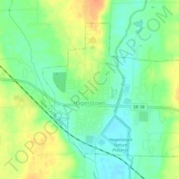
Name: Topografische Karte Hagerstown, Höhe, Relief.
Ort: Hagerstown, Wayne County, Indiana, United States (39.90306 -85.17084 39.92317 -85.14325)
Durchschnittliche Höhe: 312 m
Minimale Höhe: 295 m
Maximale Höhe: 335 m
Terrain surrounding Hagerstown consists of flat land at an elevation of roughly 1000 feet above sea level that is used primarily for agriculture.
Andere topografische Karten
Klicken Sie auf eine Karte, um ihre Topografie, ihre Höhe und ihr Relief anzuzeigen.
Spring Grove
United States > Indiana > Wayne County
Spring Grove, Wayne County, Indiana, United States
Durchschnittliche Höhe: 300 m
Boston
United States > Indiana > Wayne County
Boston, Wayne County, Indiana, 47324, United States
Durchschnittliche Höhe: 344 m
Cambridge City
United States > Indiana > Wayne County
Cambridge City, Wayne County, Indiana, United States
Durchschnittliche Höhe: 292 m
Richmond
United States > Indiana > Wayne County
Richmond, Wayne County, Indiana, 47374, United States
Durchschnittliche Höhe: 314 m
Economy
United States > Indiana > Wayne County
Economy, Wayne County, Indiana, United States
Durchschnittliche Höhe: 345 m