
Topografische Karte Spring Grove
Interaktive Karte
Klicken Sie auf die Karte, um die Höhe anzuzeigen.
Über diese Karte
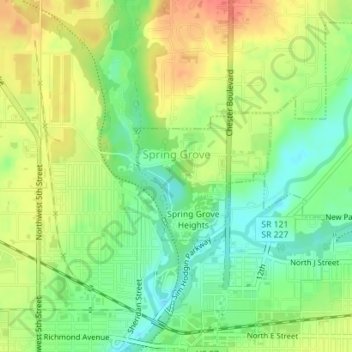
Name: Topografische Karte Spring Grove, Höhe, Relief.
Ort: Spring Grove, Wayne County, Indiana, United States (39.84174 -84.89841 39.85157 -84.88472)
Durchschnittliche Höhe: 300 m
Minimale Höhe: 276 m
Maximale Höhe: 326 m
Andere topografische Karten
Klicken Sie auf eine Karte, um ihre Topografie, ihre Höhe und ihr Relief anzuzeigen.
Boston
United States > Indiana > Wayne County
Boston, Wayne County, Indiana, 47324, United States
Durchschnittliche Höhe: 344 m
Cambridge City
United States > Indiana > Wayne County
Cambridge City, Wayne County, Indiana, United States
Durchschnittliche Höhe: 292 m
Richmond
United States > Indiana > Wayne County
Richmond, Wayne County, Indiana, 47374, United States
Durchschnittliche Höhe: 314 m
Economy
United States > Indiana > Wayne County
Economy, Wayne County, Indiana, United States
Durchschnittliche Höhe: 345 m
Hagerstown
United States > Indiana > Wayne County
Hagerstown, Wayne County, Indiana, United States
Durchschnittliche Höhe: 312 m