
Spenden
Topografische Karte Alcorcón
Klicken Sie auf die Karte, um die Höhe anzuzeigen.
Spenden
Alcorcón
The municipality, largely flat, lies at an average altitude of 711 metres above sea level, with the highest point being El Ventorro del Cano (741 m), located in the north of the municipality.
Spenden
Über diese Karte
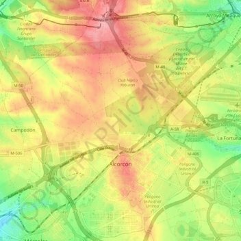
Name: Topografische Karte Alcorcón, Höhe, Relief.
Ort: Alcorcón, Community of Madrid, Spain (40.32394 -3.87879 40.40310 -3.78790)
Durchschnittliche Höhe: 692 m
Minimale Höhe: 634 m
Maximale Höhe: 742 m
Spenden
Andere topografische Karten
Klicken Sie auf eine Karte, um ihre Topografie, ihre Höhe und ihr Relief anzuzeigen.
Sierra de Guadarrama
The range runs southwest–northeast, extending from the province of Ávila in the southwest, through the Community of Madrid, to the province of Segovia in the northeast. The range measures approximately 80 kilometres (50 mi) in length. Its highest peak is Peñalara, 2,428 metres (7,966 ft) in elevation.
Durchschnittliche Höhe: 1.235 m
Spenden
La Maliciosa
Spain > Community of Madrid > Navacerrada
La Maliciosa is one of the most important and highest mountains of the Sierra de Guadarrama, a mountainous formation belonging to the Sistema Central. It has an altitude of 2227m above sea level and is located in the northwest of the Community of Madrid, in Spain, rising between La Pedriza, which lies to the…
Durchschnittliche Höhe: 1.856 m
Spenden
Fuenlabrada
Spain > Community of Madrid > Área metropolitana de Madrid y Corredor del Henares > Fuenlabrada
The founding of the village of Fuenlabrada has been tentatively traced to the late 14th century, populated by the dwellers of the nearby settlements of Loranca, Albas and Fregacedos, which had been simultaneously depopulated. The first mention of Fuenlabrada, which by the early 16th century was part of the…
Durchschnittliche Höhe: 630 m
Spenden
Loma del Rellano
Spain > Community of Madrid > Área metropolitana de Madrid y Corredor del Henares > San Sebastián de los Reyes
Durchschnittliche Höhe: 687 m