
Topografische Karte Douglas County
Interaktive Karte
Klicken Sie auf die Karte, um die Höhe anzuzeigen.
Über diese Karte
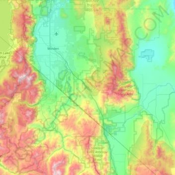
Name: Topografische Karte Douglas County, Höhe, Relief.
Ort: Douglas County, Nevada, United States of America (38.53617 -120.00343 39.11401 -119.31548)
Durchschnittliche Höhe: 1.940 m
Minimale Höhe: 1.345 m
Maximale Höhe: 3.308 m
According to the U.S. Census Bureau, the county has an area of 738 square miles (1,910 km2), of which 710 square miles (1,800 km2) is land and 28 square miles (73 km2) (3.8%) is water. It is the second-smallest county in Nevada by area. The highest point is East Peak at 9,593 ft (2,924 m), while the most topographically prominent mountain is Mount Siegel.
Andere topografische Karten
Klicken Sie auf eine Karte, um ihre Topografie, ihre Höhe und ihr Relief anzuzeigen.
Death Valley
United States of America > Nevada
Death Valley, Beatty Wash Road, Nye County, Nevada, 92328, United States of America
Durchschnittliche Höhe: 1.085 m