
Topografische Karte Death Valley
Interaktive Karte
Klicken Sie auf die Karte, um die Höhe anzuzeigen.
Über diese Karte
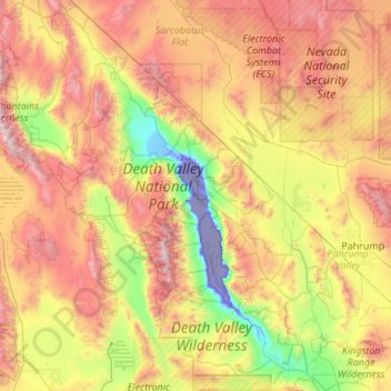
Name: Topografische Karte Death Valley, Höhe, Relief.
Durchschnittliche Höhe: 1.085 m
Minimale Höhe: -83 m
Maximale Höhe: 3.329 m
Death Valley's Badwater Basin is the point of the lowest elevation in North America, at 282 feet (86 m) below sea level. This point is 84.6 miles (136.2 km) east-southeast of Mount Whitney, the highest point in the contiguous United States, with an elevation of 14,505 feet (4,421 m). On the afternoon of July 10, 1913, the United States Weather Bureau recorded a high temperature of 134 °F (56.7 °C) at Furnace Creek in Death Valley. This temperature stands as the highest ambient air temperature ever recorded at the surface of the Earth.
Andere topografische Karten
Klicken Sie auf eine Karte, um ihre Topografie, ihre Höhe und ihr Relief anzuzeigen.
Douglas County
United States of America > Nevada
Douglas County, Nevada, United States of America
Durchschnittliche Höhe: 1.940 m