
Topografische Karte Villanúa
Interaktive Karte
Klicken Sie auf die Karte, um die Höhe anzuzeigen.
Über diese Karte
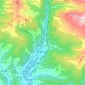
Name: Topografische Karte Villanúa, Höhe, Relief.
Ort: Villanúa, Jacetania, Huesca, Aragon, 22870, Spain (42.64379 -0.56716 42.73401 -0.44207)
Durchschnittliche Höhe: 1.499 m
Minimale Höhe: 895 m
Maximale Höhe: 2.872 m
Villanúa (in Aragonese: Bellanuga[1][2]) is a Pyrenean municipality in Spain in the north of Huesca province, in la Jacetania, set where the Aragon valley gets wider. Its name refers to the "new village" repopulated in the late 10th century. Villanúa's altitude is 953 m and it covers 58.2 km2. The village is at the bottom of mount Collarada (2886 m) and in 2018 had 447 inhabitants.
Andere topografische Karten
Klicken Sie auf eine Karte, um ihre Topografie, ihre Höhe und ihr Relief anzuzeigen.