
Topografische Karte Jaca
Interaktive Karte
Klicken Sie auf die Karte, um die Höhe anzuzeigen.
Über diese Karte
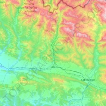
Name: Topografische Karte Jaca, Höhe, Relief.
Ort: Jaca, Jacetania, Huesca, Aragon, Spain (42.41503 -0.70159 42.82795 -0.39912)
Durchschnittliche Höhe: 1.223 m
Minimale Höhe: 576 m
Maximale Höhe: 2.993 m
Jaca has an submediterranean climate (Köppen: Cfb) bordering a submediterranean climate (Köppen: Cfa) with strong continental influences caused by the city's high altitude of 820 metres (2,690 ft). Winters are cool and summers are warm, with hot daytime temperatures but relatively cool nights. There isn't any real dry season, but the rainiest seasons are autumn and spring. The average precipitation is 768 millimetres (30.2 in) per year. Frost is common so is snowfall, being snow common from late November to early March. Heavy snowfalls are sporadic, and they usually occur during cold spells. Jaca's average annual temperature is 12.2 °C (54.0 °F).
Andere topografische Karten
Klicken Sie auf eine Karte, um ihre Topografie, ihre Höhe und ihr Relief anzuzeigen.