
Topografische Karte Banff National Park
Interaktive Karte
Klicken Sie auf die Karte, um die Höhe anzuzeigen.
Über diese Karte
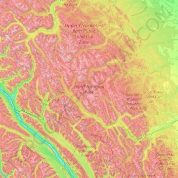
Name: Topografische Karte Banff National Park, Höhe, Relief.
Ort: Banff National Park, Alberta, Canada (50.70506 -117.31712 52.27145 -115.16491)
Durchschnittliche Höhe: 1.848 m
Minimale Höhe: 773 m
Maximale Höhe: 3.472 m
Banff National Park has a subarctic climate with three ecoregions, including montane, subalpine, and alpine. The forests are dominated by Lodgepole pine at lower elevations and Engelmann spruce in higher ones below the treeline, above which is primarily rocks and ice. Mammal species such as the grizzly bear, cougar, wolverine, elk, bighorn sheep and moose are found, along with hundreds of bird species. Reptiles and amphibians are also found but only a limited number of species have been recorded. The mountains are formed from sedimentary rocks which were pushed east over newer rock strata, between 80 and 55 million years ago. Over the past few million years, glaciers have at times covered most of the park, but today are found only on the mountain slopes though they include the Columbia Icefield, the largest uninterrupted glacial mass in the Rockies. Erosion from water and ice have carved the mountains into their current shapes.
Andere topografische Karten
Klicken Sie auf eine Karte, um ihre Topografie, ihre Höhe und ihr Relief anzuzeigen.
Brooks
Canada > Alberta > City of Brooks
Brooks, City of Brooks, Alberta, Canada
Durchschnittliche Höhe: 758 m
King Edward Park
Canada > Alberta > Division No. 11 > Edmonton
King Edward Park, Mill Creek South, Edmonton, Division No. 11, Alberta, Canada
Durchschnittliche Höhe: 671 m
Town of Mayerthorpe
Canada > Alberta > Division No. 13
Town of Mayerthorpe, Division No. 13, Alberta, T0E 1N0, Canada
Durchschnittliche Höhe: 711 m
Mount Roberta
Canada > Alberta > Division No. 15
Mount Roberta, Division No. 15, Alberta, Canada
Durchschnittliche Höhe: 2.051 m
Moab Lake
Canada > Alberta > Division No. 15
Moab Lake, Division No. 15, Alberta, Canada
Durchschnittliche Höhe: 1.336 m
Drayton Valley
Canada > Alberta > Division No. 11
Drayton Valley, Division No. 11, Alberta, Canada
Durchschnittliche Höhe: 839 m
Mount Esau
Canada > Alberta > Division No. 15
Mount Esau, Division No. 15, Alberta, Canada
Durchschnittliche Höhe: 2.521 m
Calmar
Canada > Alberta > Division No. 11
Calmar, Division No. 11, Alberta, T0C 0V0, Canada
Durchschnittliche Höhe: 731 m
Mount K2
Canada > Alberta > Division No. 15
Mount K2, Division No. 15, Alberta, Canada
Durchschnittliche Höhe: 2.548 m
Stony Plain
Canada > Alberta > Division No. 11
Stony Plain, Division No. 11, Alberta, Canada
Durchschnittliche Höhe: 711 m
Rutherford
Canada > Alberta > Division No. 11 > Edmonton
Rutherford, Heritage Point, Heritage Valley, Edmonton, Division No. 11, Alberta, Canada
Durchschnittliche Höhe: 692 m
Westridge
Canada > Alberta > Division No. 11
Westridge, Wolf Willow, West Jasper Place, Division No. 11, Alberta, Canada
Durchschnittliche Höhe: 669 m
Cardiff
Canada > Alberta > Division No. 11
Cardiff, Division No. 11, Alberta, T8R 1S1, Canada
Durchschnittliche Höhe: 701 m
Copper Mountain
Canada > Alberta > Division No. 15
Copper Mountain, Division No. 15, Alberta, Canada
Durchschnittliche Höhe: 2.280 m
Balzac
Canada > Alberta > Rocky View County
Balzac, Rocky View County, Alberta, T0M 0E0, Canada
Durchschnittliche Höhe: 1.088 m
Raymond (town)
Raymond (town), Alberta, T0K 2S0, Canada
Durchschnittliche Höhe: 1.051 m
Summer Village of White Sands
Canada > Alberta > Division No. 7
Summer Village of White Sands, Division No. 7, Alberta, Canada
Durchschnittliche Höhe: 786 m
Chip Lake
Canada > Alberta > Division No. 14
Chip Lake, Division No. 14, Alberta, Canada
Durchschnittliche Höhe: 808 m
Namur Lake 174A
Canada > Alberta > Wood Buffalo
Namur Lake 174A, Wood Buffalo, Alberta, Canada
Durchschnittliche Höhe: 732 m
Toronto Peak
Canada > Alberta > Division No. 15
Toronto Peak, Division No. 15, Alberta, Canada
Durchschnittliche Höhe: 2.423 m
County of Minburn
County of Minburn, Alberta, T8N 7V2, Canada
Durchschnittliche Höhe: 671 m
Municipal District of Willow Creek No. 26
Municipal District of Willow Creek No. 26, Alberta, T0L 0Z0, Canada
Durchschnittliche Höhe: 1.231 m
Highlands
Canada > Alberta > Division No. 11
Highlands, Greater Highlands, Division No. 11, Alberta, Canada
Durchschnittliche Höhe: 650 m
Crowsnest Pass
Canada > Alberta > Division No. 15
Crowsnest Pass, Municipality of Crowsnest Pass, Division No. 15, Alberta, T0K 0E0, Canada
Durchschnittliche Höhe: 1.512 m
Starling
Canada > Alberta > Division No. 11
Starling, Big Lake, Division No. 11, Alberta, Canada
Durchschnittliche Höhe: 678 m
Roche Noir
Canada > Alberta > Improvement District No. 12
Roche Noir, Improvement District No. 12, Alberta, Canada
Durchschnittliche Höhe: 2.306 m
Waterton Lakes National Park
Canada > Alberta > Improvement District No. 04
Waterton Lakes National Park, Improvement District No. 04, Alberta, T0K 2M0, Canada
Durchschnittliche Höhe: 1.778 m
Wandering River
Canada > Alberta > Athabasca County
Wandering River, Athabasca County, Alberta, T0A 3M0, Canada
Durchschnittliche Höhe: 575 m
Fox Creek
Canada > Alberta > Town of Fox Creek
Fox Creek, Town of Fox Creek, Alberta, T0H 1P0, Canada
Durchschnittliche Höhe: 834 m