Topografische Karte Calgary
Interaktive Karte
Klicken Sie auf die Karte, um die Höhe anzuzeigen.
Über diese Karte
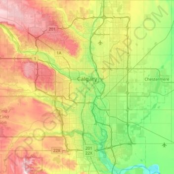
Name: Topografische Karte Calgary, Höhe, Relief.
Ort: Calgary, Alberta, Canada (50.84253 -114.31576 51.21250 -113.86000)
Durchschnittliche Höhe: 1.106 m
Minimale Höhe: 957 m
Maximale Höhe: 1.349 m
Calgary experiences a semi-monsoonal humid continental climate (Köppen climate classification Dwb) within eastern parts of the city and a subarctic climate (Köppen climate classification Dwc) within western parts of the city due to an increase in elevation. The city has warm, comfortable summers and freezing, dry (but like all of Alberta extremely variable) winters. It falls into the NRC Plant Hardiness Zone 4a. According to Environment Canada, average daily temperatures in Calgary range from 16.5 °C (61.7 °F) in July to −7.1 °C (19.2 °F) in January.
Andere topografische Karten
Klicken Sie auf eine Karte, um ihre Topografie, ihre Höhe und ihr Relief anzuzeigen.
Banff National Park
Banff National Park, Alberta, Canada
Durchschnittliche Höhe: 1.848 m
Bluffton
Canada > Alberta > Division No. 8
Bluffton, Division No. 8, Alberta, Canada
Durchschnittliche Höhe: 926 m
Red Deer Lake
Canada > Alberta > Foothills County
Red Deer Lake, Foothills County, Alberta, Canada
Durchschnittliche Höhe: 1.140 m
Jasper National Park
Canada > Alberta > Division No. 15
Jasper National Park, Division No. 15, Alberta, Canada
Durchschnittliche Höhe: 1.782 m
King Edward Park
Canada > Alberta > Division No. 11 > Edmonton
King Edward Park, Mill Creek South, Edmonton, Division No. 11, Alberta, Canada
Durchschnittliche Höhe: 671 m
Brooks
Canada > Alberta > City of Brooks
Brooks, City of Brooks, Alberta, Canada
Durchschnittliche Höhe: 758 m
Town of Mayerthorpe
Canada > Alberta > Division No. 13
Town of Mayerthorpe, Division No. 13, Alberta, T0E 1N0, Canada
Durchschnittliche Höhe: 711 m
Mount Roberta
Canada > Alberta > Division No. 15
Mount Roberta, Division No. 15, Alberta, Canada
Durchschnittliche Höhe: 2.051 m
Moab Lake
Canada > Alberta > Division No. 15
Moab Lake, Division No. 15, Alberta, Canada
Durchschnittliche Höhe: 1.336 m
Drayton Valley
Canada > Alberta > Division No. 11
Drayton Valley, Division No. 11, Alberta, Canada
Durchschnittliche Höhe: 839 m
Mount Esau
Canada > Alberta > Division No. 15
Mount Esau, Division No. 15, Alberta, Canada
Durchschnittliche Höhe: 2.521 m
Calmar
Canada > Alberta > Division No. 11
Calmar, Division No. 11, Alberta, T0C 0V0, Canada
Durchschnittliche Höhe: 731 m
Mount K2
Canada > Alberta > Division No. 15
Mount K2, Division No. 15, Alberta, Canada
Durchschnittliche Höhe: 2.548 m
Stony Plain
Canada > Alberta > Division No. 11
Stony Plain, Division No. 11, Alberta, Canada
Durchschnittliche Höhe: 711 m
Rutherford
Canada > Alberta > Division No. 11 > Edmonton
Rutherford, Heritage Point, Heritage Valley, Edmonton, Division No. 11, Alberta, Canada
Durchschnittliche Höhe: 692 m
Westridge
Canada > Alberta > Division No. 11
Westridge, Wolf Willow, West Jasper Place, Division No. 11, Alberta, Canada
Durchschnittliche Höhe: 669 m
Cardiff
Canada > Alberta > Division No. 11
Cardiff, Division No. 11, Alberta, T8R 1S1, Canada
Durchschnittliche Höhe: 701 m
Copper Mountain
Canada > Alberta > Division No. 15
Copper Mountain, Division No. 15, Alberta, Canada
Durchschnittliche Höhe: 2.280 m
Balzac
Canada > Alberta > Rocky View County
Balzac, Rocky View County, Alberta, T0M 0E0, Canada
Durchschnittliche Höhe: 1.088 m
Raymond (town)
Raymond (town), Alberta, T0K 2S0, Canada
Durchschnittliche Höhe: 1.051 m
Summer Village of White Sands
Canada > Alberta > Division No. 7
Summer Village of White Sands, Division No. 7, Alberta, Canada
Durchschnittliche Höhe: 786 m
Chip Lake
Canada > Alberta > Division No. 14
Chip Lake, Division No. 14, Alberta, Canada
Durchschnittliche Höhe: 808 m
Namur Lake 174A
Canada > Alberta > Wood Buffalo
Namur Lake 174A, Wood Buffalo, Alberta, Canada
Durchschnittliche Höhe: 732 m
Toronto Peak
Canada > Alberta > Division No. 15
Toronto Peak, Division No. 15, Alberta, Canada
Durchschnittliche Höhe: 2.423 m
County of Minburn
County of Minburn, Alberta, T8N 7V2, Canada
Durchschnittliche Höhe: 671 m
Municipal District of Willow Creek No. 26
Municipal District of Willow Creek No. 26, Alberta, T0L 0Z0, Canada
Durchschnittliche Höhe: 1.231 m
Highlands
Canada > Alberta > Division No. 11
Highlands, Greater Highlands, Division No. 11, Alberta, Canada
Durchschnittliche Höhe: 650 m
Crowsnest Pass
Canada > Alberta > Division No. 15
Crowsnest Pass, Municipality of Crowsnest Pass, Division No. 15, Alberta, T0K 0E0, Canada
Durchschnittliche Höhe: 1.512 m
Starling
Canada > Alberta > Division No. 11
Starling, Big Lake, Division No. 11, Alberta, Canada
Durchschnittliche Höhe: 678 m
Roche Noir
Canada > Alberta > Improvement District No. 12
Roche Noir, Improvement District No. 12, Alberta, Canada
Durchschnittliche Höhe: 2.306 m
Waterton Lakes National Park
Canada > Alberta > Improvement District No. 04
Waterton Lakes National Park, Improvement District No. 04, Alberta, T0K 2M0, Canada
Durchschnittliche Höhe: 1.778 m