
Topografische Karte Cuyapo
Klicken Sie auf die Karte, um die Höhe anzuzeigen.
Über diese Karte
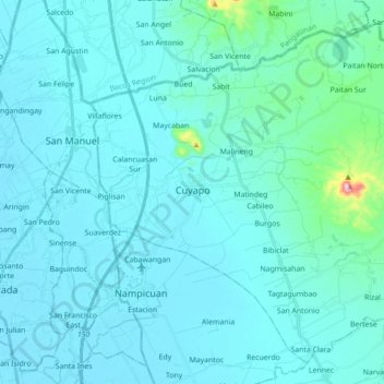
Name: Topografische Karte Cuyapo, Höhe, Relief.
Ort: Cuyapo, Nueva Ecija, Central Luzon, 3117, Philippines (15.70166 120.61507 15.85131 120.79044)
Durchschnittliche Höhe: 41 m
Minimale Höhe: 14 m
Maximale Höhe: 369 m
Andere topografische Karten
Klicken Sie auf eine Karte, um ihre Topografie, ihre Höhe und ihr Relief anzuzeigen.
Lupao
Philippines > Nueva Ecija > Lupao
Lupao belongs to the first type of climate in the Philippines. This type of climate has two (2) pronounced seasons: dry from the month of November to April and Wet during the rest of the year. This type of climate is typically hot, humid and tropical and is generally affected by the neighboring topography and…
Durchschnittliche Höhe: 163 m
General Tinio
Farming is the livelihood of majority of the residents. Even though located at the foot of the Sierra Madre Mountain Ridges, the topography is generally plain ideal to agricultural products such as palay and vegetables. A number of poultry broiler contract growers are located in the municipality. Other…
Durchschnittliche Höhe: 54 m