
Spenden
Topografische Karte Tarn-et-Garonne
Klicken Sie auf die Karte, um die Höhe anzuzeigen.
Spenden
Tarn-et-Garonne
The central part of the department is a broad river valley that does not exceed 150 m (492 ft) in altitude, but near the commune of Valence-d'Agen, in the extreme west of the department, the valley narrows as the hilly regions of Bas-Quercy to the north and Lomagne to the south draw closer together. In the northeast of the department is higher land in the form of limestone plateaus known as the Causses, part of the Massif Central. The highest point in the department, at 510 m (1,673 ft), is the Pech Maurel, situated in the commune of Castanet.
Spenden
Über diese Karte
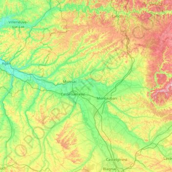
Name: Topografische Karte Tarn-et-Garonne, Höhe, Relief.
Ort: Tarn-et-Garonne, Occitania, Metropolitan France, France (43.76743 0.73781 44.39389 2.00087)
Durchschnittliche Höhe: 172 m
Minimale Höhe: 36 m
Maximale Höhe: 520 m
Spenden
Andere topografische Karten
Klicken Sie auf eine Karte, um ihre Topografie, ihre Höhe und ihr Relief anzuzeigen.
Spenden
Hôtellerie du Cirque
France > Occitania > Hautes Pyrenees > Gavarnie-Gèdre > Gavarnie
Durchschnittliche Höhe: 1.989 m
Pic de Finestrelles
France > Occitania > Pyrénées-Orientales > Eyne
Pic de Finestrelles is a mountain located in the Oriental Pyrenees, on the border of France and Spain. It has an altitude of 2,826 metres (9,272 ft) above sea level.
Durchschnittliche Höhe: 2.502 m
Spenden
Pic de Finestrelles
France > Occitania > Pyrénées-Orientales > Eyne
Pic de Finestrelles is a mountain located in the Oriental Pyrenees, on the border of France and Spain. It has an altitude of 2,826 metres (9,272 ft) above sea level.
Durchschnittliche Höhe: 2.502 m
Spenden
Spenden
Spenden
Spenden
Spenden
Spenden
Spenden
Mont Valier
France > Occitania > Ariège > Seix
On August 18, 2023, French general Jean-Louis Georgelin fell to his death while hiking on Mont Valier, at an altitude of 2,650 metres (8,690 ft).
Durchschnittliche Höhe: 2.217 m
Spenden
Spenden
Spenden
Spenden
Spenden
Odeillo
France > Occitania > Pyrénées-Orientales > Font-Romeu-Odeillo-Via
Durchschnittliche Höhe: 1.631 m
Cirque de Gavarnie
France > Occitania > Hautes Pyrenees > Gavarnie-Gèdre > Gavarnie
Durchschnittliche Höhe: 2.364 m
Spenden
Spenden
Spenden
Réserve naturelle de Roque-Haute
France > Occitania > Hérault > Portiragnes
Durchschnittliche Höhe: 11 m
Spenden
Spenden
Spenden
Riuros
France > Occitania > Pyrénées-Orientales > Saint-Laurent-de-Cerdans
Durchschnittliche Höhe: 759 m
Spenden
Spenden
La Ville
France > Occitania > Pyrénées-Orientales > Saint-Laurent-de-la-Salanque
Durchschnittliche Höhe: 4 m
Spenden
Lac de Gaube
France > Occitania > Hautes Pyrenees > Cauterets
The lake is situated in an altitude of 1725 m, an egg-shaped form stretching itself along a north–south axis in the valley of Gaube. This steep-sided valley is located at the foot of the Vignemale (3298M). The lake is surrounded by the peak Mayouret (2688 m) to the east, the big Peak of the Paloumères (2720…
Durchschnittliche Höhe: 2.079 m
Spenden
Spenden