
Topografische Karte Harrison County
Interaktive Karte
Klicken Sie auf die Karte, um die Höhe anzuzeigen.
Über diese Karte
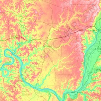
Name: Topografische Karte Harrison County, Höhe, Relief.
Ort: Harrison County, Indiana, USA (37.95869 -86.33109 38.42240 -85.89986)
Durchschnittliche Höhe: 205 m
Minimale Höhe: 115 m
Maximale Höhe: 308 m
Andere topografische Karten
Klicken Sie auf eine Karte, um ihre Topografie, ihre Höhe und ihr Relief anzuzeigen.
Middle Fork of Wildcat Creek
Middle Fork of Wildcat Creek, Clinton County, Indiana, 46065, USA
Durchschnittliche Höhe: 215 m
Fort Branch
USA > Indiana > Fort Branch
Fort Branch, Gibson County, Indiana, 47648, USA
Durchschnittliche Höhe: 136 m
Dearborn County
Sparta Township, Dearborn County, Indiana, 47032, USA
Durchschnittliche Höhe: 267 m
Saint Henry
USA > Indiana > Saint Henry
Saint Henry, Dubois County, Indiana, USA
Durchschnittliche Höhe: 160 m
Lawrenceburg
USA > Indiana > Lawrenceburg
Lawrenceburg, Lawrenceburg Township, Dearborn County, Indiana, USA
Durchschnittliche Höhe: 168 m
Holmesville
USA > Indiana > Holmesville
Holmesville, LaPorte County, Indiana, 46391, USA
Durchschnittliche Höhe: 240 m