Geolokalisieren
👉 Easily get elevation data in JSON, GeoTIFF and KML formats using Elevation API
Vielen Dank für die Unterstützung dieser Website ❤️
Spenden

Topografische Karte Trafford

Klicken Sie auf die Karte, um die Höhe anzuzeigen.

👉 Easily get elevation data in JSON, GeoTIFF and KML formats using Elevation API
Vielen Dank für die Unterstützung dieser Website ❤️
Spenden

Über diese Karte

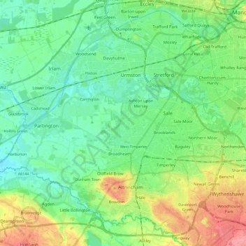
Name: Topografische Karte Trafford, Höhe, Relief.

Ort: Trafford, Greater Manchester, England, United Kingdom (53.35741 -2.47845 53.48039 -2.25302)

Durchschnittliche Höhe: 32 m

Minimale Höhe: 8 m

Maximale Höhe: 86 m

👉 Easily get elevation data in JSON, GeoTIFF and KML formats using Elevation API
Vielen Dank für die Unterstützung dieser Website ❤️
Spenden

Andere topografische Karten

Klicken Sie auf eine Karte, um ihre Topografie, ihre Höhe und ihr Relief anzuzeigen.

London

United Kingdom > England > London

Durchschnittliche Höhe: 42 m

Cambridge

United Kingdom > England > Cambridge

The city, like most of the UK, has a maritime climate highly influenced by the Gulf Stream. Located in the driest region of Britain, Cambridge's rainfall averages around 570 mm (22.44 in) per year, around half the national average, with some years occasionally falling into the semi-arid (under 500 mm (19.69…

Durchschnittliche Höhe: 18 m

Huddersfield

United Kingdom > England > Kirklees

Durchschnittliche Höhe: 145 m

Reading

United Kingdom > England > Reading

Mary Russell Mitford lived in Reading for a number of years and then spent the rest of her life just outside the town at Three Mile Cross and Swallowfield. The fictional Belford Regis of her eponymous novel, first published in 1835, is largely based on Reading. Described with topographical accuracy, it is…

Durchschnittliche Höhe: 56 m

Vielen Dank für die Unterstützung dieser Website ❤️
Spenden

Milton Keynes

United Kingdom > England > Milton Keynes > Milton Keynes

Durchschnittliche Höhe: 81 m

Leeds

United Kingdom > England

Lying in the eastern foothills of the Pennines, there is a significant variation in elevation within the city's built-up area. The district ranges from 1,115 feet (340 m) in the far west on the slopes of Ilkley Moor to about 33 feet (10 m) where the rivers Aire and Wharfe cross the eastern boundary. Land rises…

Durchschnittliche Höhe: 94 m

Derby

United Kingdom > England > Derbyshire

Durchschnittliche Höhe: 97 m

Bedford

United Kingdom > England > Bedford

As with the rest of the United Kingdom, Bedford has a maritime climate, with a limited range of temperatures, and generally even rainfall throughout the year. The nearest Met Office weather station to Bedford is Bedford (Thurleigh) airport, about 6.5 miles (10.5 km) north of Bedford town centre at an elevation…

Durchschnittliche Höhe: 37 m

Vielen Dank für die Unterstützung dieser Website ❤️
Spenden

Leicester

United Kingdom > England > City of Leicester

Durchschnittliche Höhe: 109 m

Gleadless Common

United Kingdom > England > Sheffield

Durchschnittliche Höhe: 177 m

Brierley Hill

United Kingdom > England

Durchschnittliche Höhe: 122 m

Kenilworth

United Kingdom > England > Kenilworth

Durchschnittliche Höhe: 89 m

Vielen Dank für die Unterstützung dieser Website ❤️
Spenden

Plymouth

United Kingdom > England > Devon > Plymouth

The River Plym, which flows off Dartmoor to the north-east, forms a smaller estuary to the east of the city called Cattewater. Plymouth Sound is protected from the sea by the Plymouth Breakwater, in use since 1814. In the Sound is Drake's Island which is seen from Plymouth Hoe, a flat public area on top of…

Durchschnittliche Höhe: 81 m

Greasby

United Kingdom > England

Durchschnittliche Höhe: 32 m

Islington

United Kingdom > England

Durchschnittliche Höhe: 30 m

Streatham

United Kingdom > England

Durchschnittliche Höhe: 37 m

Vielen Dank für die Unterstützung dieser Website ❤️
Spenden

Crewkerne

United Kingdom > England > South Somerset > Crewkerne

Durchschnittliche Höhe: 88 m

Portsmouth

United Kingdom > England > Hampshire > Portsmouth

By road, Portsmouth lies 73.5 miles (118.3 km) from Central London, 49.5 miles (79.7 km) west of Brighton, and 22.3 miles (35.9 km) east of Southampton. Portsmouth is situated primarily on Portsea Island and is the United Kingdom's only island city, although parts of it have expanded onto the mainland. Gosport…

Durchschnittliche Höhe: 28 m

Ely

United Kingdom > England > Ely

For over 800 years the cathedral and its associated buildings—built on an elevation 68 feet (21 m) above the nearby fens—have visually influenced the city and its surrounding area. Geographer John Jones, writing in 1924, reports that "from the roof of King's Chapel in Cambridge, on a clear day, Ely can be…

Durchschnittliche Höhe: 13 m

Middlesbrough

United Kingdom > England > Middlesbrough

Durchschnittliche Höhe: 26 m

Vielen Dank für die Unterstützung dieser Website ❤️
Spenden

Accrington

United Kingdom > England > Lancashire > Hyndburn

Geographical coordinates: 53° 46' 0" North, 2° 21' 0" West. Height above sea level: there is a spot height outside the Market Hall which is 133.5 metres (438 ft) the benchmark on the side of the neighbouring Town Hall is 441.10 feet (134.45 m). The highest height in the town is 320 metres (1,050 ft) which is…

Durchschnittliche Höhe: 199 m

Ambleside

United Kingdom > England > Westmorland and Furness

Durchschnittliche Höhe: 212 m

Orpington

United Kingdom > England > Greater London

Durchschnittliche Höhe: 89 m

Vielen Dank für die Unterstützung dieser Website ❤️
Spenden

Hull

United Kingdom > England > Kingston upon Hull

Kingston upon Hull is on the northern bank of the Humber Estuary. The city centre is west of the River Hull and close to the Humber. The city is built upon alluvial and glacial deposits which overlie chalk rocks but the underlying chalk has no influence on the topography. The land within the city is generally…

Durchschnittliche Höhe: 21 m

Durham

United Kingdom > England > County Durham

Durchschnittliche Höhe: 119 m

Warmley

United Kingdom > England > South Gloucestershire

Durchschnittliche Höhe: 69 m

Box

United Kingdom > England > Gloucestershire > Stroud

Durchschnittliche Höhe: 142 m

Vielen Dank für die Unterstützung dieser Website ❤️
Spenden

Ormesby St Margaret

United Kingdom > England > Norfolk > Great Yarmouth

Durchschnittliche Höhe: 8 m

Grays

United Kingdom > England > Essex

Durchschnittliche Höhe: 14 m

Bushby

United Kingdom > England > Leicestershire > Harborough

Durchschnittliche Höhe: 113 m

Vielen Dank für die Unterstützung dieser Website ❤️
Spenden

Norwich

United Kingdom > England > Norfolk > Norwich

Durchschnittliche Höhe: 29 m

Cambridge

United Kingdom > England > Cambridgeshire

The city, like most of the UK, has a maritime climate highly influenced by the Gulf Stream. Located in the driest region of Britain, Cambridge's rainfall averages around 570 mm (22.44 in) per year, around half the national average, The driest recent year was in 2011 with 380.4 mm (14.98 in) of rain at the…

Durchschnittliche Höhe: 33 m

Norton

United Kingdom > England > Doncaster > Norton

Durchschnittliche Höhe: 18 m

Haworth

United Kingdom > England > Bradford

Durchschnittliche Höhe: 243 m

Vielen Dank für die Unterstützung dieser Website ❤️
Spenden

Dulwich Park

United Kingdom > England > London

Durchschnittliche Höhe: 47 m

Ottershaw

United Kingdom > England > Surrey > Borough of Runnymede

Durchschnittliche Höhe: 33 m

Scafell Pike

United Kingdom > England > Cumberland

Scafell Pike (/ˈskɔːfɛl paɪk/) is the highest and the most prominent mountain in England, at an elevation of 978 metres (3,209 ft) above sea level. It is located in the Lake District National Park, in Cumbria, and is part of the Southern Fells and the Scafell massif.

Durchschnittliche Höhe: 679 m

Queensbury

United Kingdom > England > Bradford

Durchschnittliche Höhe: 284 m

Vielen Dank für die Unterstützung dieser Website ❤️
Spenden

Worksop

United Kingdom > England > Nottinghamshire > Bassetlaw

Durchschnittliche Höhe: 56 m

Corfe Mullen

United Kingdom > England > Corfe Mullen

Durchschnittliche Höhe: 52 m

Chard

United Kingdom > England > Somerset

Chard is a town and a civil parish in the English county of Somerset. It lies on the A30 road near the Devon and Dorset borders, 15 miles (24 km) south west of Yeovil. The parish has a population of approximately 13,000 and, at an elevation of 121 metres (397 ft), Chard is the southernmost and one of the…

Durchschnittliche Höhe: 135 m

Wallsend

United Kingdom > England > Tyne and Wear > North Tyneside

Durchschnittliche Höhe: 41 m

Vielen Dank für die Unterstützung dieser Website ❤️
Spenden

Okehampton

United Kingdom > England > Okehampton

Durchschnittliche Höhe: 252 m

Heathfield

United Kingdom > England > East Sussex > Wealden

Durchschnittliche Höhe: 99 m

Brighton

United Kingdom > England > Brighton and Hove

Durchschnittliche Höhe: 28 m

Royal Tunbridge Wells

United Kingdom > England > Kent > Tunbridge Wells

Durchschnittliche Höhe: 99 m

Vielen Dank für die Unterstützung dieser Website ❤️
Spenden

Carlisle

United Kingdom > England > Cumberland

Durchschnittliche Höhe: 31 m

Poole Bay

United Kingdom > England

Durchschnittliche Höhe: 0 m

Middleton

United Kingdom > England

Durchschnittliche Höhe: 113 m

Rawmarsh

United Kingdom > England

Durchschnittliche Höhe: 64 m

Vielen Dank für die Unterstützung dieser Website ❤️
Spenden

Walthamstow

United Kingdom > England

Durchschnittliche Höhe: 21 m

Rugby

United Kingdom > England > Warwickshire > Rugby > Rugby

Durchschnittliche Höhe: 106 m

Teddington

United Kingdom > England

Durchschnittliche Höhe: 17 m

Hackney

United Kingdom > England

Durchschnittliche Höhe: 17 m

Vielen Dank für die Unterstützung dieser Website ❤️
Spenden

York

United Kingdom > England > York

Durchschnittliche Höhe: 21 m

The Mount

United Kingdom > England > Devon > South Hams > Totnes

Durchschnittliche Höhe: 70 m

Leigh

United Kingdom > England

Durchschnittliche Höhe: 34 m

Tottenham

United Kingdom > England > Greater London

Tottenham's elevation is approximately 33 ft (10 m) above sea level.

Durchschnittliche Höhe: 25 m

Vielen Dank für die Unterstützung dieser Website ❤️
Spenden

The Wells

United Kingdom > England > Surrey > Epsom and Ewell

Durchschnittliche Höhe: 63 m

South Nutfield

United Kingdom > England > Surrey

Durchschnittliche Höhe: 88 m

Coseley

United Kingdom > England > Dudley

Durchschnittliche Höhe: 155 m

Manea

United Kingdom > England > Cambridgeshire > Fenland District

Durchschnittliche Höhe: 1 m

Vielen Dank für die Unterstützung dieser Website ❤️
Spenden

Glastonbury Tor

United Kingdom > England > Somerset > Glastonbury

Durchschnittliche Höhe: 33 m

Birkenhead

United Kingdom > England

Durchschnittliche Höhe: 24 m

Dewsbury

United Kingdom > England > Kirklees

Durchschnittliche Höhe: 91 m

Vielen Dank für die Unterstützung dieser Website ❤️
Spenden

Banbury

United Kingdom > England > Cherwell > Banbury

Durchschnittliche Höhe: 119 m

Honiton

United Kingdom > England > Honiton

Durchschnittliche Höhe: 158 m

Witcombe

United Kingdom > England > Somerset > Ash

Durchschnittliche Höhe: 21 m

Vielen Dank für die Unterstützung dieser Website ❤️
Spenden

Clyst Heath

United Kingdom > England > Devon > Exeter > Topsham

Durchschnittliche Höhe: 26 m

Roborough

United Kingdom > England > Devon > South Hams

Durchschnittliche Höhe: 123 m

River Ouse

United Kingdom > England > East Sussex > Newhaven > South Heighton

Durchschnittliche Höhe: 21 m

Burslem

United Kingdom > England > Stoke-on-Trent

Durchschnittliche Höhe: 157 m

Vielen Dank für die Unterstützung dieser Website ❤️
Spenden

Upper Holloway

United Kingdom > England > Derbyshire > Amber Valley > Holloway

Durchschnittliche Höhe: 189 m

Kirklees

United Kingdom > England > Bury > Tottington

Durchschnittliche Höhe: 154 m

Oakhill

United Kingdom > England > Somerset

Durchschnittliche Höhe: 227 m

Darley Park

United Kingdom > England > Derby > Derby

Durchschnittliche Höhe: 62 m

Vielen Dank für die Unterstützung dieser Website ❤️
Spenden

Mere Green

United Kingdom > England > Worcestershire > Wychavon > Hanbury

Durchschnittliche Höhe: 62 m

Yeovilton

United Kingdom > England > Somerset

Durchschnittliche Höhe: 20 m

Rootham's Green

United Kingdom > England > Bedford

Durchschnittliche Höhe: 65 m

Forest of Arden

United Kingdom > England > Reading > Reading

Durchschnittliche Höhe: 64 m

Vielen Dank für die Unterstützung dieser Website ❤️
Spenden

Graveney

United Kingdom > England > Kent > Borough of Swale

Durchschnittliche Höhe: 8 m

Langham

United Kingdom > England > Rutland

Durchschnittliche Höhe: 135 m

Aby

United Kingdom > England > Lincolnshire > East Lindsey

Durchschnittliche Höhe: 23 m

Vielen Dank für die Unterstützung dieser Website ❤️
Spenden

Middleton Priors

United Kingdom > England > Shropshire > Ditton Priors

Durchschnittliche Höhe: 220 m

Bathwick Hill

United Kingdom > England > Bath and North East Somerset > Bath

Number 1 (Bathwick Lodge) is a 2-storey villa with a steep Mansard room, built in 1825, extended in 1840 and the late C19. Probably by John Pinch the Elder.[4] Number 2 is from the early 19th century and has shutters over the windows.[11] Number 3 includes a porch which is elaborately enriched with carving,…

Durchschnittliche Höhe: 93 m

Tamworth

United Kingdom > England > Staffordshire > Tamworth > Tamworth

Durchschnittliche Höhe: 76 m

Allesley

United Kingdom > England > Coventry

Durchschnittliche Höhe: 115 m

Vielen Dank für die Unterstützung dieser Website ❤️
Spenden

Yarcombe

United Kingdom > England > East Devon > Yarcombe

Durchschnittliche Höhe: 171 m

Kettering

United Kingdom > England > Kettering

Durchschnittliche Höhe: 92 m

Stoney Cove

United Kingdom > England > Leicestershire > Stoney Stanton

Durchschnittliche Höhe: 86 m

Birdholme

United Kingdom > England > Derbyshire > Chesterfield

Durchschnittliche Höhe: 109 m

Vielen Dank für die Unterstützung dieser Website ❤️
Spenden

Langton Green

United Kingdom > England > Kent > Tunbridge Wells

Durchschnittliche Höhe: 94 m

Ilkley Moor

United Kingdom > England > Bradford

Durchschnittliche Höhe: 259 m

High Legh

United Kingdom > England > High Legh

Durchschnittliche Höhe: 60 m

Billinge Hill

United Kingdom > England > St Helens

Billinge Hill is in the Metropolitan Borough of St Helens in North West England. With a maximum elevation of 179 m (587 ft), it is the highest point of Merseyside. It lies in Billinge, within the historic county boundaries of Lancashire, and it is one of the 176 hills graded as a Marilyn in England.

Durchschnittliche Höhe: 115 m

Vielen Dank für die Unterstützung dieser Website ❤️
Spenden