
Spenden
Topografische Karte Tiefenbronn
Klicken Sie auf die Karte, um die Höhe anzuzeigen.
Spenden
Tiefenbronn
The municipality (Gemeinde) of Tiefenbronn covers 14.79 square kilometers (5.71 sq mi) of the Enzkreis, a district of Baden-Württemberg, Germany. It is located on the edge of the Black Forest and the Upper Gäu [de]. The buntsandstein of the Röt Formation, under the Black Forest, extends into the municipal area from the west as far east as the border with Heimsheim. North and south of the buntsandstein are the wooded and karstified hills of muschelkalk of the Heckengäu. The main watercourse is the Würm, a tributary of the Enz that flows through Tiefenbronn in several meanders. The lowest elevation above sea level, 325 meters (1,066 ft) Normalnull (NN), is found where the Würm forms the border with Pforzheim. The highest elevation is 526 meters (1,726 ft) NN, on the northern slope of the Büchelberg.
Spenden
Über diese Karte
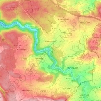
Name: Topografische Karte Tiefenbronn, Höhe, Relief.
Durchschnittliche Höhe: 448 m
Minimale Höhe: 325 m
Maximale Höhe: 536 m
Spenden
Andere topografische Karten
Klicken Sie auf eine Karte, um ihre Topografie, ihre Höhe und ihr Relief anzuzeigen.
Holzbachtal
Germany > Baden-Württemberg > Enzkreis > Straubenhardt > Langenalb
Durchschnittliche Höhe: 449 m
Spenden